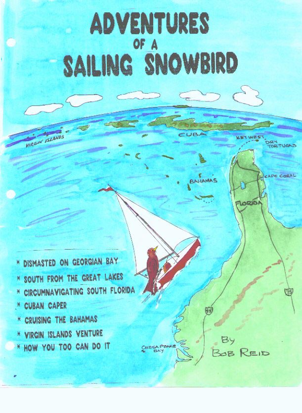
Introduction
This book's written style is like letters you would send to your friends about your trip. The purpose was for enjoyment, to supply information and, to encourage participation.
Excerpts from some of these stories have appeared in "GAM on Yachting" magazine.
Although my wife Josephine does not like to sail, she encourages me to enjoy my sailing hobby. Therefore I am free to make my own decisions about when and where to sail, which has obvious advantages. She also encouraged me to combine my stories into this book. This gives further proof to the belief that behind most happy men, there is a good woman. Thanks also to my son Robert John, who reviews my stories.
The people I have sailed with and who have sailed with me also deserve a thank-you. We have all learned something from each other.
Peter Froggatt deserves a special mention for the information he supplied for the "South from the Great Lakes" story as do Ray Howe, and Tom Martin for the advice provided.
I hope you enjoy the book. May the winds be on your stern quarter.
Bob Reid,
The Sailing Snowbird.
Contents
Chapter 1 Dismasted on Georgian Bay
Chapter 2 South from the Great Lakes.
(North Channel, Lake Huron to Oswego N.Y.)
Chapter 3 South from the Great Lakes.
(Oswego to Annapolis MD.)
Chapter 4 South from the Great Lakes.
(Return: Buffalo, NY to the North Channel)
Chapter 5 Circumnavigating South Florida
Chapter 6 Cuban Caper
Chapter 7 Cruising the Bahamas with Mr. Claus
in a boat called Mary Christmas
Chapter 8 Virgin Islands Venture
Chapter 9 How You Too Can Do It.
To my grandchildren:
They are my son Ryan's children, Sherri, Alexander, Robert, and Ryan Reid. Also to my daughter Cynthia's children Elizabeth and Adam Varano.
I pray that they have a life that is at least as enjoyable as mine has been, since it continues to be a blissful existence. I trust they get the education and training they need to find an occupation they will enjoy, which is an important part of a good life. Hopefully this allows them to build on the introduction I have given them to sailing, and leads to an enjoyable retirement, if that is their desire.
Dismasted on Georgian Bay
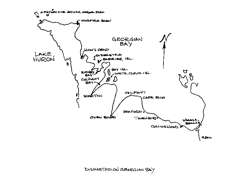
Geogian Bay is the large bay you can see on a map of the great lakes, located on the east side of Lake Huron. The bay is about 125 miles (202 Km) long, 50 miles (81 km) wide, and up to 450 feet (91 m) deep. It is actually large enough to be the sixth great lake. The winds in the summer are, about 60 per cent of the time, from the north west. It is unusual for the waves, in the relatively protected bay, in the summer time, to get over 8 feet high. The sketch of the locale of the trip shows Bruce Peninsula, the strip of land between Lake Huron and the bay. The picturesque hills along the peninsula are part of the Niagara escarpment that forms the famous falls some 150 miles to the S.E.
This was my fifth year in the Georgian Bay Regatta, I had crewed with John Blais on Chalet de Mer a Hunter 35.5 five years ago. John had done a great job as Regatta Chairman the previous three years, which is now(1996) ably Chaired by Derry Ironside. During John's tenure I was race score keeper.
A few weeks prior to the Regatta I had gone up to Killarney, on the N.W. corner of G. B., to help John bring his boat back to Meaford for repair. He unfortunately ran into an uncharted rock at the Bustards in the channel on the N. E. side of the bay. The wing keel on the Hunter found a pinnacle of rock bringing the boat to an abrupt stop. His wife, Beverly had tumbled from the cockpit into the cabin, taking a serious fall, and breaking an arm, a leg and knocking out some teeth. She recovered from this very well, but the dental work required the most protracted treatment. Beverly still managed to take the helm while docking at a fishing camp nearby, so she could be taken to the hospital.
A few years ago one of the boats I had crewed on was Glen Lowe's` sloop, "Felicity". Glen has also been a G.B.R. chairman. The other years I had taken my power boat that also took part as one of the committee boats, but it was unavailable because I had sold it earlier in the year. This year I decided to crew on a boat involved in racing, to get a change from score keeping. Consequently I contacted Frank Murphy about crewing on "Raider" his 30 ft. C&C Mega. I contacted Frank because I also race my own 30 ft. Mega in Florida and knew he was a competitive racer. Frank has also acted as regatta handicapper as long as I've known him.
This was Frank's second year with the Mega that replaced a Catalina 27. Frank and his wife Mabel had completely reconditioned the boat for this year's race. The bottom paint was completely removed, resealed and repainted. The interior cushions were recovered, vee bunks added, and interior refinished. Running back stays were added, as well as a new jib, and many other small improvements.
On registration day for the regatta we met in Thornbury on the S. W. shore, then moved my car to Meaford, and went farther N. W., to Wiarton, the regatta starting point. Frank had previously trailered the boat to Wiarton.
Besides Mabel and myself for crew there was Andy McClellan, who crewed on the boat on Lake Simcoe, where they usually sailed. We had a pleasant day helping Frank measure sails and renewing old acquaintances.
The next day the race was from Wiarton to Sidney Bay. There were four fleets and we were in the last to start.
On the way out, we noticed a couple in a canoe off to one side taking video pictures. The next thing we knew they were along side bouncing off our hull. The lady got excited and jumped overboard. Fortunately she was a good swimmer but could not get back into the canoe without tipping it over. So we got her on to "Raider", then back into the canoe, unhurt. Little did we realize at the time that this incident was a foreboding of future events.
We had a good start and were doing well going up Colpoys Bay, the winds were light when we came to Hay Island, at the mouth of the bay. At this point we made the decision to go inside the island as the winds were expected to go Northwest. However, this never happened so those who went outside got better winds and came in ahead. This resulted in a disappointing mid-fleet finish.
That afternoon we had a swim in Sidney Bay and a delicious meal cooked by Mabel, our first mate.
The next day we were looking forward to improving our finish. We started well and were on a reach out of the bay. As soon as we cleared it we put up the spinnaker. About three miles further on, N.W. of Barrier Island, the winds were moving forward and we were rounded up a couple of times, so we decided to take down the spinnaker. Frank and Andy were on the foredeck, Mabel on the helm, I was manning the main sheet.
The jib was up and we were about to take down the spinnaker when the fore stay gave away at the bow. The mast paused for a brief second, there was cracking sound as the unsupported mast tore the mast step out of the deck, Mabel yelled, "Watch out, Bob!". We stepped to the other side of the cockpit, and the mast came down where we had been standing. Mabel and I were buried under the main sail. We pulled the sail back to gape at a wild tangle of sails , stays and shrouds. For a few seconds we didn't know where to start with the mess that stared back into our unbelieving eyes. Nobody was hurt.
Fortunately there were lots of boats around and the seas were only a couple of feet high. That is a great thing about the G.B.R.: you have lots of help in case of an emergency. The committee power boat stood by, and "Take Time" a Bayfield 29 owned and crewed by Louis and Rika Coortscame along side. Louis came onboard to help us straighten out the mess.
First we tied the mast so it would not go completely overboard. Except that the mainsail was stubborn, the sails came off easily enough. I thought about diving in to untangle the main halyard from the top of the mast, but it came free eventually.
Once that was done we started coiling up shrouds and stay wires and securing them with duck tape (don't leave home without it). We got the mast onboard and supported by the cradle used for trailering. Things were eventually cleared enough to get under way by motor. The committee boat left us to be escorted by "Take Time" into Lion's Head, so Frank could get more fuel for a return to Wiarton. After arranging for repairs Frank and Mabel followed the regatta by auto.
At Lion's Head I transferred to "Take Time" for a ride to Windfield Basin where we were having a barbecue at the light house which was under restoration with the help of G.B.S.C. and others.
From there Glen Lowes who already had a crew of four, kindly took me onboard Felicity his Tanzer 26 sloop. It was fortunate that the Tanzer is well laid out for its length with bunks for five.
The other crew members were Milt Edwards, Bill Hill, and Billy Abbott. Billy had left a bike at Lions Head, our next race destination, so he could bike the rest of the trip to Thornbury.
We had medium winds and a pleasant race into Lion's Head from Windfield. That evening there was a good meal put on by a local service club.
The next day we had a race back to the west side of White Cloud Island at Colpoys Bay. The Tanzer is not a gung ho racing boat but we didn't come in last.
When we were anchored and relaxing with a beer some fellows came by in a rubber dinghy armed with water filled balloons. Our cannons consisted of three buckets which proved to be heavier artillery than the water balloons. Our attackers were doused but not defeated. They returned with buckets to get revenge. We were laughing too hard by this time to put up a good defense. After a meal, a few more beers, and a song or two, we retired for another race day.
The next day we had rain and mist, but no wind for our race to Meaford. Everyone followed the committee boats towards our destination in search of some wind.
After about five miles, adjacent to Cape Commodore, more grief, our diesel abruptly stopped. I was beginning to wonder if misfortune was chasing me or vice versa.
We were taken under tow by another sailboat "Nana & Popa II". Getting our heads together while under tow, we decided to try the fuel filter that had been a problem when I was on the boat a few years ago. I took about a pint of water out of the filter but it still wouldn't start. Milt bled the fuel lines and it finally started chugging along again.
When we reached the marker off Vail Point they decided to call off the race. After we turned the point at Cape Rich, towards Meaford, the wind picked up, but most were not disappointed by this time except for a few ardent racers.
Since I had left my car at Meaford, I went from there to Wasaga Beach, my home port, but returned to Thornbury the final destination for the wind-up banquet.
Next year the regatta is back to the east side of Georgian Bay. I wonder what sailing adventures we'll have next year. No more dismastings I hope. In the meantime we look forward to sailing in Florida.
South from the Great Lakes
North Channel, Lake Huron to Oswego N.Y.
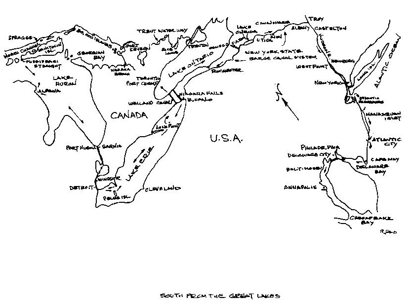
The trip started in the renown North Channel of Lake Huron, whichsome call the Caribbean of the north. There is some similarity to the Sir Francais Drake Channel in the U.S. and British Virgin Islands. The 37 ft. Alberg "Wanesa" planned to visit this area, on the start of a proposed year-long cruise and back .
The captain-owner, Geoff, lived in Sudbury about 80 miles from the North Channel Yacht Club, at Spragge. Travelling back and forth added no small amount to the chore of getting the boat ready for the trip.
Most of the crew, including myself, had been recruited through an ad in a sailing magazine. We had individually gone to see Geoff in Sudbury for a get-acquainted meeting.
The other crew on the Annapolis leg consisted of Chuck who was going all the way to the Virgins, and Pete a retired merchant marine officer who is a skilled navigator. Pete and I were going to Annapolis with Pete leaving from Spragge while, I was joining the boat in Port Credit near Toronto, replacing Don who only did the first part of the trip. The first few days were spent helping Geoff get the boat ready. We were to find out later that Geoff unfortunately had problems with depression, which explained some of the friction that was to occur later in the voyage.
Some of the things the crew attended to in those first few days were part of Geoff's plan, such as installing a helmsman's seat in the cockpit and making wooden fenders for use in the canal locks. But they also had to spend quite some time fixing up problems that increasingly began to show up as they went along, such as the discovery of a number of leaks at the port holes and deck fittings after a torrential downpour during their first night on board. "Wanesa" was a twenty year old boat, unfortunately beginning to show her age, especially when faced with a voyage of this magnitude. However, during those first few days everyone was optimistic and enthusiastic for the start of the adventure. They were unaware at that stage of the various other problems we would encounter as the voyage progressed. One of the first of these, for example, was in getting the sanitary holding tank pumped out. Geoff had a problem with the onboard plumbing, which he had been working hard to fix up. But then, the club's shore-side pumpout equipment wouldn't work when they went alongside to use it. Problems in both regards were to pursue them for some time and it wasn't until they got to Port Credit, about two weeks later, that they were finally able to get their first pumpout.
A navigation problem arose. This trip took place before the GPS system had come out but, the boat had a second hand Satnav that Geoff had recently purchased. It however, had some problems in addition to the fact that it relied on a few satellites that were only available every few hours. This made it of limited use in the close quarters of the Great Lakes.
On the evening of the Wednesday before they sailed, after all of the hard work on the plumbing, and discovering the deficiencies of the poorly functioning SAT NAV, they were rewarded with a total eclipse of the moon in a brilliantly clear star-filled sky. And on the Thursday morning just before sailing a number of photos were taken to mark their moment of departure. Then they were off on a bright, warm sunny day, passing though the beautifully wild scenery of water, rocks and trees that forms much of the appeal of the legendary North Channel. There was little wind, however, and they had to motor virtually all the way on a southwest course towards the west end of Manitoulin Island and the Mississagi Strait between it and Cockburn Island.
They took hourly turns at the wheel and began to get the feel of the vessel, and they raised and lowered the sails a couple of times in what turned out to be futile attempts to sail. But as they passed the dolomite loading facility and approached the Southern end of the strait, and as the day began to draw to a close, they finally got a good wind and they sailed along quite well for awhile towards the south-southeast, enroute down the length of Lake Huron. But the wind didn't last. As the moon rose full in another brilliantly clear sky they floated in a flat calm, the light on Great Duck Island shining brightly to the east as they took turns standing solitary watches under a canopy of stars, shooting stars, and northern lights. Later during the night the wind picked up again they hoisted sail for a while. But again the wind died away and it was then they all turned in for the final few hours before dawn.
As they started the second day there was no land in sight once Great Duck Island disappeared over the horizon. But they were not alone. They could see freighters from time to time passing in the distance, and around them they saw cormorants, gulls, loons and even a butterfly. By noon they were off Alpena, Michigan, but the only wind they had, while it gave them good sailing, was heading them away from the US shore. Later on in the evening, the wind first died down a bit and they motored for a while, and then it picked up again and in fact became quite strong. Later the increasing wind became so strong that they were moving along at maximum speed in what were, by then, rough seas. As it worked out, they got little sleep that night.
Sailing that night was not made easier by the fact that the binnacle light quit. As there was no light on the knotmeter and the only ship's flashlight had a broken bulb, they could see neither instruments nor the masthead wind indicator. Fortunately the sky was quite clear and there was an abundance of stars to steer by. Pete had no problem using them to best advantage. Also he had a small, personal pocket flashlight which was pressed into service to give occasional, brief glimpses of the compass and knotmeter, although its beam was not powerful enough to reach the masthead wind indicator.
When daylight came, the wind died away again and they began to motor. But not for long. As they all sat in the cockpit, Don was the first to notice the smell of a burning odour. It turned out to be an engine overheating problem caused by a failed gasket in the cooling water pump. This was soon rectified and they carried on, motor sailing now and heading back towards the US shore. Soon it became quite busy with small boats, since it was now Saturday and there were a lot of weekend boaters out.
They were not quite sure of their position. Although they had seen some lights during the last hours of darkness earlier on, the small scale chart they had didn't show any, and they had no list of lights on board. They tried the RDF (Radio Direction Finder) but got nothing useful from it, probably because they were beyond the 10 to 25 mile range of most of the am radio stations listed for that coast. They estimated they were somewhere off the mouth of Saginaw Bay. Later, around noon, Pete was able to recognize some of the features of Harbour Beach, Michigan, which were so distinctive that they showed up even on the small scale chart. And a meridian passage sight he took for practise soon afterwards confirmed their latitude there.
During the afternoon they partly sailed and partly motored, continuing on their southward course towards Sarnia. They were all looking forward to getting to the Yacht Club there for a good night's sleep and also relishing the expectation of being able to get a shower. As it turned out, however, they wouldn't get into harbour that day.
Approaching Sarnia, the various shipping lanes converge towards the relatively narrow entrance to the St. Clair River. They knew they would have to be extra alert. It was getting quite dark and later it began to rain. But the channel was well buoyed, and the one or two large freighters around were brightly lit. Just as they were entering the main part of the channel, however, under power, the engine quit! They didn't know why at the time, and in any case, their first priority became getting clear of the channel and away from the shipping.
They sailed away to the east while they tried to get things sorted out. There were many lights around, but not too many easily recognizable, in addition, they all began to fade as the rain closed in. Fortunately the well illuminated distinctive shape of the Blue Water Bridge stayed visible most of the time. By using this as their main reference point, eventually they were able to feel their way into reasonably shallow water off Brights Cove, several miles east of Sarnia. There they anchored at about midnight. Despite the excitement of the previous few hours, sheer exhaustion a sound sleep ensued that night.
The next morning they awoke to a grey, wet and windy day with poor visibility. The engine problem turned out to be a failed fuel pump. Geoff, having brought along a spare one soon had it installed and the engine going again. Then they were off to Sarnia, paralleling the shoreline and dodging fishing floats and racing sailboats (even in that weather!) before finally turning into the yacht club entrance. Once there they then found that they were very lucky to get a berth, since the local sailing club was hosting the MOR-C racing regatta that was starting that very day. Hence the sailboats were out!
They also had other problems with the boat. After having had the engine quit on them the day before, they found that when they tried to leave the fuel dock, where they had checked in, to go to their assigned berth, the engine now wouldn't start. Geoff was able to jump start it so that they could get to the berth, but of course, it gave one more thing to fix. It turned out to be the solenoid switch on the starter motor. Being in port enabled them to go ashore for parts, and they bought not only a replacement solenoid, but also another spare fuel pump and various other items, such as a second flashlight with spare batteries and bulbs for them both. They were also able to get the showers they wanted and do some grocery shopping, but a planned laundry trip fell through when they could not find a laundromat. They also discovered that the pumpout facility at the yacht club did not have a fitting to match Wanesa's outlet! The problem of not being able to get a pumpout was really brought home to them that evening when the system overflowed on board just after they had all turned in. They had to endure a rather smelly hour or so of cleaning and ventilating before they could turn in again.
The next morning, Monday, was sunny and clear. Some of Geoff's relatives from southern Ontario came to the boat and they all had a delightful visit with them, enjoying also the abundance of food and drink they had brought for them.
Eventually these visitors left, however, and as by then they had also done all their required repairs, shopping etc., it was time for them to go too.
One outstanding concern was the lack of charts of the St. Clair River, Lake St. Clair and Detroit River areas, that they were now about to enter. As an alternative to buying the three charts required, at the last minute Geoff was given a small scale, faintly printed reproduction of a chart on glossy paper, little more than an advertising folder and clearly not intended for navigation. But that was all that they had and so that was what they had to use.
They left the yacht club at about 4 pm and almost immediately passed under the Blue Water Bridge, that had been the great saving landmark for them two days earlier. They then had an exciting four hour run down the river, sharing it with several freighters and various other small boats. At the end of the river, near where it widened out into the fairly large but shallow Lake St. Clair, Geoff tried to anchor just outside the channel. But it was so shallow they kept touching bottom and eventually they had to journey on, well out into the lake itself, in darkness now, where evenually at about 10:30 pm they found an anchorage in 14 feet of water off the northern part of Detroit.
They got off to an early start next morning on an overcast and foggy day. Leaving our anchorage they quickly re-entered the buoyed channel leading to the Detroit River. By the time they entered the river and were passing between Windsor on the one side and Detroit on the other, it had started to rain, although it did not last. They passed under the Ambassador Bridge, but because of the weather they could take no photos. They then proceeded down the river for several hours, passing and meeting some other vessels along the way, about noon, they cleared the river and headed out into Lake Erie.
Immediately they were plunging in rough seas and having overlooked securing the forehatch, took a wave on board which soaked everything below! They hoisted sail and tried different combinations of main and jib, eventually settling for the jib alone. In the fairly strong wind they found themselves making a good six to seven knots. They decided to head for Scudder, on the north end of Pelee Island, not wishing to attempt the difficult and busy Pelee Island passage after dark.
At about 2 o'clock that afternoon, they heard an immediate severe weather warning on the VHF radio. But although they saw some ominous black clouds in the distance, they had only the dull, grey, damp, rough weather they had had all along. Eventually they saw Pelee Island appearing low on the horizon, and by late afternoon they were tied up, after several attempts, as Geoff changed his mind about where he wanted to be in the tiny harbor. There was no marina or showers at Scudder, which was in fact a very small place. One of the features they noticed was the evident tradition of carving boat names into the planking of the dock.
This island is the southern most point of Canada and produces some the best wines in North America; however, they did not take time for a winery tour. Some think of Canada as far north but, Pelee Island is on the same latitude as nothern California.
After a good supper (generally speaking we ate very well all the time) they spent an enjoyable evening under a clear starry sky, talking to two school psychologists, in the next boat alongside in the dock, who were also avid sailors.
They got off to another early start the next morning on a day that was again overcast and muggy. They had to navigate carefully by course and distance while they made way through the dog-legged but well marked Pelee Island Passage, with the great beacons reassuringly looming out of the mist at the right times and places. Once clear of the channel, they set course towards the northeast, on what was to be one of the longest legs they would sail. Heading directly for Long Point and then the approaches to the Welland Canal. There was a good north wind so they were soon sailing along quite smartly, trying everything from the spinnaker to a reefed mainsail.
During the afternoon the sun started to break through the grey cloudy sky as they enjoyed some good sailing. As an added hazard they found extensive areas of underwater natural gas well heads on the Canadian side of the lake that were mark by unlit buoys that were not marked on the chart they had. This was discouvered just as the daylight began to fade. Partly to avoid these buoys and partly because the wind veered to the northeast, they had to turn away and head more towards the US shore. The waves built up and that night became one of the roughest they experienced, with little sleep for any of them. Lost in the blackness of the night in the middle of the lake, they had only some uncertain RDF bearings to use to try to keep track of where they were. Eventually they saw some lights to the south, and as dawn broke they deduced that they were off Erie, Pennsylvania.
Not wanting to be driven down any further, they had to turn away. The only option was to go north, virtually into the teeth of the wind and waves in order to cross the lake and seek shelter in the lee of the Canadian shore. It was sunny with cloudy periods as they started the motor, but then Geoff had Pete and Chuck hoist the sails again and they were soon beating into the brisk wind. As the day progressed the wind got stronger and the waves built up. They soon realized they were overpowered. But they kept on pounding along, everything getting tossed about below and the crashing spray finding more places on deck to get through.
When they eventually sighted Long Point, they found they were well east of it. While this was good as it was in the direction they wanted to go, it also meant that they had to continue right on up to the shore on the north side of Long Point Bay to find the shelter they were seeking. Eventually in the early afternoon, after passing some fishing boats and an oil platform, they began to get into the lee followed by subsequent easing of the seas. They continued to press northwards. Pete had warned Geoff that they should turn away to the east while they were still well offshore. Pete had not been able to fix their position with cross bearings, since, the only identifiable land mark was the Nanticoke Power Plant which gave only one position line. But there were two considerations in Geoff's mind, one making as much to windward as possible before tacking, if they were to continue sailing, and the other to get as much as possible into the lee of the land to facilitate motoring along the shore, if that is what they were going to do.
Eventually, using the power plant, Pete plotted a danger bearing, but even as he was still trying to observe it with the hand bearing compass, he was called off to help furl the mainsail, Geoff having decided that they were going to turn and motor, which they then did. But they soon found out that they were too close in to the shore, because shortly afterwards they hit bottom on what turned out to be Cunningham Reef. Unfortunately this time it was rock rather than soft mud, but fortunately, a shelf rather than a pinnacle.
Quickly they turned away and got back into deeper water, as far as they knew undamaged. They headed out until they were well clear before turning again on course towards the east. Rather than attempting to go as far as Port Colborne and the Welland Canal that day, it was decided that they would only go as far as Port Maitland, as they were all now getting fatigued.
Later that afternoon in warm sunshine and by now calm water, as they motored in towards the harbour entrance at Port Maitland, they stopped for a while. Geoff and Don went skinny dipping to refresh themselves, although they were somewhat taken aback by the strength of the current they found. Pete preferred to wait until they were docked at the small, but very friendly and welcoming Port Maitland Sailing Club, where a hot shower was available. After another good supper on board, everyone was soon ready for an early night.
They got off to one of their usual early starts in the cool, clear morning of the next day. There was a brisk wind out on the lake, but it was not favorable for their course to Port Colborne and so they had to motor. They arrived at about 11 am. By then it was sunny, bright and, ideal for a passage through the Welland Canal. However, they found that they could not get through until later that day. Then, each time Geoff phoned back to the lock master at the times prescribed, it was to learn of more and more delays. All day they waited, taking the opportunity of doing some shopping, and generally looking around and observing the shipping going through the canal.
It wasn't until eleven at night that they were given the word that they could go through. The alternative being to wait until the following morning if they wanted a daytime passage, with no guarantee that they would get one even then. And so that night, in clear but quite cool weather, they passed through the canal in the company of two American power boats.
The canal was well lit and they soon picked up the coloured light signal codes used at various locks. But it was a long passage. They had to tie up along the wall several times and just sit and wait. Although, in the locks, they quickly got used to rafting up alongside one of the power boats, which made it easier for us since they had the more difficult job of holding their boat off from the dock walls. They were just behind a freighter and our passage was governed by the time it needed to get into, through and then out of each lock. All night they moved along in a haze of fumes from its funnel. At dawn they were still not completely through, but the increasing light at least enabled them to see some of the passing scenery. Soon after it got light they passed under the Garden City Skyway at St. Catharines. Finally at 9 am, some ten hours after they had started, tired after a night's work, they cleared the canal and exited into a flat calm Lake Ontario.
Just prior to this they had debated whether they should stop for a while and catch up on their sleep before crossing to Port Credit. But finally they decided against sleeping and carried on. It was a fine, calm morning, with a smooth lake as they motored across on a direct line to their destination. Soon a heavy smog became visible along the northern horizon, although it did clear somewhat as they got closer. Then the CN Tower and the new Skydome in Toronto showed up, followed by the entire shoreline from Toronto to Oakville. It was about noon when they neared the entrance to the Credit River. Being Saturday, with the Great Salmon Derby still in full swing, it was incredibly busy with small fishing boats, many, if not most of which were totally ignoring the right of way rules! The guest docks at Port Credit Yacht Club were also all full, but they had been invited to stay and there was a berth waiting for them. But first they went to the fuel dock, not only for fuel but also for the all important pumpout that they had not been able to get so far. Fortunately a suitable fitting was available and the pump out was at long last completed. Once in the assigned berth, the priorities became sleep and getting home. Don's trip was finished here, so he was planning to head back to Sudbury. Chuck wanted to get home to Powassan for a few days. And as Toronto was Pete's home town, he also planned to sleep at home until they sailed again. But their host at Port Credit first invited them on board his boat for a drink and also, it turned out, had arranged for a barbecue supper for them at his nearby home. This they couldn't refuse and thoroughly enjoyed. Then it was back on board to sleep and in Pete's case, go home.
During "Wanesa's" several days in Port Credit, Pete was down at the boat each day, helping Geoff with the many things that still needed to be done. One evening they had a gathering in the cockpit with their wives and several people who were planning to join as crew later on. One threat to the continuation of the voyage at this time was the difficulty Geoff had in getting offshore insurance, but this was finally resolved. Later that week Chuck returned and I joined the crew, replacing Don, for the next portion of the voyage. We all stored our gear, settled in and got ready to sail again.
We left after lunch on the Thursday, a bright sunny day. We went first across the river to the fuel dock, to dump some oil in the facility provided, and then it was down the river and out into Lake Ontario. It was fairly busy with fishing boats again, but we soon cleared them and then set course almost directly east towards Oswego, on the US Shore. Soon we were passing the Toronto skyline and could see, in addition to all the office highrises and the CN Tower, that the Skydome sports area was open. The wind was fair, the lake smooth, and we had good sailing. We settled in quickly to our previous routine of one hour turns on the wheel during the day, changing to two hour turns at night, with Geoff on full time standby.
At midnight we were still enjoying good sailing, although the seas had built up. Glows on the horizon to port and starboard indicated the locations of urban areas in Canada and the US. Later conditions became rougher and by dawn it was also overcast with light rain. Then about 7 o'clock the wind first backed and then died. We started to motor and later we tried to get some RDF bearings. ( We were still trying to figure out the Satnav.) Eventually, however, they became unnecessary as we saw, looming through the mist, the two huge chimneys of the power plant, a positive landmark for Oswego. We were right on course.
The wind picked up again and we began to sail, heading more upwind as Geoff sought to gain ground to windward. But now the wind increased abruptly and whitecaps began to show up everywhere. The waves built up even more and sailing became quite difficult. It was soon quite evident that we were overpowered. First we turned away, more to the south, but eventually we had to furl the jib and put the motor on. Now the rain became heavy, along with all the spray as well, visibility became limited. But we could still see the two chimneys and so were able to keep ourselves oriented. At noon we were all out in the cockpit keeping watch and eating our lunch in the rain as we approached the harbour entrance. It continued to pour down as we entered the harbour, motored up the river and finally tied up at the marina near the mast removal dock. The Great Lakes portion of the voyage was now over.
South from the Great Lakes
Oswego, N.Y. to New York, N.Y.
Once berthed at Oswego, we first sought US Customs and Immigration clearance from whom we purchased our cruising certificate. While this process was going on, we did some shopping in the nearby stores. Then we did some work on the boat while in our hot foul weather gear. The rain was quite heavy at times and, consequently Pete was very annoyed with Geoff when he found he had opened the porthole above his bunk to "ventilate the boat", allowing the driving rain to soak some of his gear. Later on we did a bit more shopping and then we were all glad to call it a day at about five o'clock. We were all weary, having had only a disturbed night's sleep the night before. After dinner there was only a relatively brief period of conversation before everyone was ready for bed.
The next morning was clear, although quite windy, which at least helped us dry out our gear. We prepared for the mast haul-out and then did various other jobs as we waited for our turn at the haul-out dock. This process, which did not go as smoothly as it should have, was finally finished just before noon. Part of the problem was Geoff trying to tell these very experienced workmen how they should lower his mast. We returned to our berth, where we finished the job of chocking off and securing the mast and its related gear ready for our passage as a power boat only now, through the New York State canal system.
After lunch we did a bit of last minute shopping and then, in the fine afternoon weather, we all trooped up to the nearby Fort Ontario for an interesting visit. As well as touring the Fort, we watched students dressed as Federal troops of the Civil War period put on drills as well a mock battle. Then it was back to the boat and our departure into the canal system.
There was no chart onboard of the overall system, but only some photostated copies of some of the more complicated sections of the canal. However, the whole route was well buoyed and by experience we soon learned the signalling and lock passage routines.
We left our berth at the marina just after four pm and arrived at the first lock only moments later. It was here that we learned that on this section of the system the locks only opened once an hour, on the hour, and we had just missed an opening. We backed off and tied up alongside the high dock wall for a while and waited, taking the opportunity to look at some of the other boats docked there. Finally we moved off again and entered the first lock (Lock #8) at five o'clock. Although locking through the New York State Canal system was a new experience for all of us, we quickly learned the routine. By about five-thirty, we were through Lock #7 and by six-fifteen, we had passed through Lock #6 and were tied up immediately above it, at the very end of the dock wall. It was a cool clear evening and our location was quiet and peaceful. We enjoyed a good supper before turning in fairly early.
The next morning, Sunday, was calm and peaceful. We took our time about having breakfast and getting ourselves and the boat cleaned up before we set off once more. We passed through Lock #5 at Minetto about mid-morning and through Lock #3 at Fulton, at noon, where we tied up for lunch. It was another quiet spot and the day, by then, was sunny and quite warm. We noted that there had been no lock #4, but had noticed some ruins in a side channel, now bypassed, where it probably had been. After lunch we walked into the town to do some more shopping, making it almost four o'clock before we left to carry on, passing through Lock #2 shortly afterwards.
Each lock was giving us more experience and things seemed to be going quite well. The fenderboard we had made earlier was working well and we had each settled into a particular position for each transit. Chuck was at the bow, I was amidships with the line, Geoff was at the wheel, and Pete was at the stern. Some of the locks had smooth, steel-faced walls, while others were rough concrete. The line was passed either around a vertical cable or steel pipe, or looped around the rungs of one of several ladders and moved up as we rose, for in this part of the system we were still climbing towards higher ground.
Along the canal itself the scenery was varied. It was mostly rural, but we did pass some homes and small towns, and in some places there were derelict factories. There were also dams at some of the locks. The locks themselves we found to be beautifully maintained with lawns, shrubs, and flower beds. The facilities were all well painted, too, in the distinctive blue and yellow colours of the system. We learned that there was competition for "best" between the various locks, and they were inspected regularly. We followed the custom of complementing the lock masters on well kept locks, whenever the opportunity arose. Passage through this excellent canal system was also free. During our passage we saw numerous birds which were of interest to us all, but especially to Chuck who made a hobby of bird watching. There were many ducks, some cormorants and an occasional kingfisher. At one point, a water skier passed us and at another we saw a hot air balloon floating by high above the tree line.
It was getting on to six o'clock when we approached Lock # 1 at Phoenix, and it was here that we ran into an unhappy occurrence. Earlier we had moved into each lock almost as soon as we had arrived. We had also always gone through alone, making our passage easy. But at Lock # 1 we had to wait a full hour, which was not only tedious at the end of the day, but also allowed several following boats to catch up with us. They then entered the lock with us when it finally opened, making our last transit of the day more complicated, although not really difficult.
Unfortunately, however, it led to a confrontation between Geoff and Chuck which resulted in Chuck packing up as soon as we were tied up just beyond the lock. Geoff had long since shown himself to be a demanding skipper, prone to shouting. This had previously disturbed Chuck and Pete. It hadn't bothered Don, who was an old friend and used to it, while I tend to dismiss incidents that are not life threatening. Besides I had not been subjected to Geoff moods very long. But this last episode was the last straw as far as Chuck was concerned. It was a sad moment when he went ashore with all his gear, not even waiting to have dinner. Later, after dinner, the three of us who were left discussed some things and tried to clear the air in an effort to avoid any repetition of such an incident.
We were up early the next morning to find the boat surrounded by ducks, busily quacking, feeding and grooming. We were alongside at a small park and at the roadside beyond, there was actually a "Duck Crossing" sign. It was clear and cool with a heavy dew and a mist hanging low over the water. Apart from some fish jumping, the water was still.
Soon boats began to pass on the canal and we also got underway. We were almost at the southern end of the Oswego River section of the canal system and about 9:30 am we arrived at the junction of Three Rivers. From here the Oneida River section led east and the Seneca River section led west. We turned east, and for the next hour or so proceeded through various river and dug canal sections until we got to Lock # 23. We had intercepted the east-west Erie canal part way along and we knew we would have to continue counting down until we finally cleared Lock # 1, on the Hudson River.
Because there was only three of us now, we had to adjust our lock transit procedures. I remained amidships with the line, Geoff looked after the stern from his post at the wheel and Pete now took the bow position. We maintained this routine for all the remaining locks and it worked well. We continued with our one hour turns at the wheel, although Geoff frequently excused himself to attend to some maintenance problem with the engine or other equipment. We also found the round of cooking and cleanup duties noticeably accelerated.
Shortly before noon we arrived at Brewerton and stopped there briefly for fuel. Soon afterwards, we left the river and passed into Lake Oneida. It was sunny and bright, and although the wind was dead ahead, it wasn't too bad. It was Labour Day, though, and the lake was quite busy with boats. As we got further east, low hills began to appear on the far side of the lake, holding the promise of more interesting scenery to come.
At about three o'clock we left the lake and re-entered the canal at Sylvan Beach. We had found the entrance there a bit hard to spot, and when we did get in, it was to find it also busy with holiday weekend traffic. Soon, however, we were through the busy part and had re-entered a rather dull bush-lined section. After about an hour we passed through Lock # 22, and about a mile further on through Lock # 21, at New London. We were now at the highest elevation of this section of the canal, some 420 feet above the level of the Hudson River. From here on, rather than going up in each lock, as we had been doing so far, we would be going down instead. We tied up along the dock wall just east of the lock, where we had another quiet and peaceful evening and an early night.
The next day we were up to catch the flush of dawn. The air was cool and clear and there was a low mist on the water that quickly burned off. We had breakfast and cleaned up and then were off. Although the sun was shining, there was a fair breeze and it was rather cool out on deck. This section of the canal was a long dead straight dug area connecting across to the upper reaches of the Mohawk River. We passed under several bridges, mostly old steel trusses, although some were of more modern steel beam and concrete design. Some of the older abutments were crumbling and we passed one on which an underwater inspection was being carried out. Although there were no locks in this section, there were several control gate structures. These were in place to stop water flow in the event of a dam or lock failure. As we passed Griffiss Air Force Base a flight of four large bombers took off and passed over.
Eventually we arrived at Lock #20 where, once through , we tied up for awhile. Pete and I went ashore to do some grocery shopping, while Geoff worked some more on the battery charging problems we had been having. Although we had thought we would be at Rome, we found that we were at Whitesboro, nearer to Utica. Once back on board we had lunch, while more bombers flew overhead.
We left at 2 pm and began to look for a marina that had deisel fuel. After about half an hour we came to one in a small side channel. We asked and were told they had enough depth to accomodate the boat, but quickly found out, they did not have water deep enough. Although we did go in and get alongside we found first that we could not get the fuel we were looking for, and then that we were stuck in the mud! It was only after considerable effort that we were able to finally get ourselves out into the canal again.
We now decided to carry on to Utica, but once there found it to be of such a stark appearance from the canal, along with poor docks, that we pressed on further. Soon afterwards the countryside opened up on both sides of the canal and we could see picturesque views with hills in the background. Now the canal ran between banks that were above the level of the adjacent land as we crossed a shallow valley. Then we were back between close in, bush lined banks again. We found Lock #19 to be a unique layout with a railway bridge across it and no place to tie up, so we had little choice but to press on even further. We passed some canal vessels busy at work and then eventually late in the afternoon, we arrived at Ilion where we berthed at the marina.
Although it was only a small place it had facilities that were not available whenever we tied up at the locks. It was also quite close to the stores and shops in the town, home of the Remington Arms company. That evening after dinner Pete and I walked into town for a while and did some shopping. Later, we were able to have showers, (our first since Oswego), and top up the water tanks. In fact, we spent considerable time flushing out and re-filling the tanks. But instead of cleaning them out as we had hoped for, all we seemed to do was stir up some sediment. We never did get rid of it all. From then on had somewhat dirt laden fresh water.
The next morning Pete and I went ashore again, to do some washing at a nearby laundromat, while Geoff continued to work on the engine. Later Geoff went ashore to buy parts from an automotive store and then worked to install them once he got back. Finally at about 11 am on a sunny and quite warm day, we were able to get going.
Soon we were passing through pleasant countryside again with meadows dotted by cows. At noon we passed through Lock #18, at Jacksonburg. The countryside became quite hilly, with more farmland. A sculler passed and a train roared by noisily on the tracks that were now running parallel to the canal. At about 12:45, we arrived at Little Falls, where the canal curved through the town before getting to Lock #17. This lock had the highest lift (40.5 ft.) in the system and on the lower side, it had an unique lift gate gantry and a solid upper wall which we passed under on the way out. Just below the lock, we exchanged greetings with a party of senior citizens on an outing provided by a local service club.
We passed more control gates before getting into the particularly attractive Lock 1b at Mindenville. Shortly afterwards we arrived at the St. Johnsville marina where we wanted to fuel up. It was very quiet and very hot! There was no one around, but we found a note on the door of the open office telling us to phone for service. We did this and a few minutes later a pickup truck arrived with an attendant who turned on the pumps for us. Soon we had topped up the tank and were underway again.
The countryside was opening up more and more now and the river was wider, so that there were buoys to mark the channel. At Lock #15 at Fort Plain, there was the first of the long sluice gate structures, that were to become common. Some were for sluices only, while others sometimes had a road or railway crossing them. Also at Lock #15 a group of soberly and uniformly dressed Amish men, women, and children, watched our progress into the lock. They all walked along to where we were and as we waited for the gates to close behind us and the water to go down we chatted with them. They asked about our trip and told us they farmed nearby. Only the three men actually spoke to us, the women and children standing silently behind them. But they did all smile and wave to us as we moved out of the lock.
Now the river valley was quite wide and we could see a nearby freeway. Soon we got to Lock #14, at Canajoharie, where we tied up above the lock. Just before, having seen no other boats all that day, we had passed a Canadian boat from Vancouver, obviously well worn from a long voyage. It was cooler by now and the evening calm and clear, but there was quite a bit of noise from the nearby freeway and railway which rather disturbed our sleep that night.
We were just finishing breakfast the next morning, when we got word from the dockmaster that he was going to lower the water in the lock for an upbound boat waiting below. So we hurriedly moved into the lock and with that, we were on our way again. It was quite misty and with the breeze it was rather cool. Soon we entered a hilly section that was worth a try for a photo even though the conditions were not very good. Later the mist burned off, but by then, the scenery was less spectacular, although still very pleasant. We passed through Lock #13 and proceeded on, the river quite wide now, with the channel well buoyed. We began to pass more riverside development, and later, the "Auriesville Shrine".
We stopped above Lock #12 at Tribes Hill for a while and Pete did some chores, Geoff and I explored around. We were having a late lunch when we saw another boat coming down, and when the lock opened for it, we quickly cast off and went through also. Shortly afterwards we arrived at Schoharie the location of a small museum of the old canal. We stopped to examine the canal history and original construction. Then we were off again and soon passed through Lock #11, at Amsterdam, and tied up below it. We went into town to do some shopping, but it was rather a dreary place with not much available. Back near the boat was Guy House, a historic location of the Johnson family. We had a brief tour before we went back on board and cast off. We passed through Lock #10, at Cranesville, at about 4:30 pm and then passed some delightful cliff scenery before arriving at, and tying up, above Lock #9, at Rotterdam Jct., at about six o'clock. As the sun was going down we had supper at a picnic table, in the park adjacent to the dock wall.
It was misty again when we got up early the next morning, but not enough to delay our departure, at about eight o'clock. We quickly cleared Lock #9 and about an hour later Lock #8. As the river was widening more and more as we began to pass islands. Two canoeists kept up with us for a while, they turned off, and then some other boats appeared. There was also more and more development along the riverbanks, including a number of factories at Schenectady. We had rather a long wait at Lock #7, where there was also a long, high dam across the river. As we knew that the next several locks were rather closely spaced, we had an early lunch, so that we would be free to deal with them.
By 12:30 we were virtually at the end of the Mohawk River section, above a dam to the right and with what was called Guard Gate #1, on the left. We had to wait a while for it to open. Then we were through and into the rocky cut leading to the last few locks at Waterford, stepping down steeply 169 ft. to the Hudson River. We moved through Lock #6 at 1 pm and then, after another wait, through Lock #5 then immediately into the adjacent Lock #4. But here we had another delay because for quite some time the lockmaster could not get the electrically driven gates to close behind us.
Eventually we moved through and were soon in Lock #3. The whole area was now more urban and built up. The locks just didn't have the attractive appeal of the earlier sections. Finally about 3 pm, we were through Lock #2. We now passed out of the canal and on to the Hudson River. Only the federally operated No.1 Control lock at Troy lay ahead. When we got down to it, we were ordered to wait until a work barge had been put in first. Then we entered along with several other boats. No longer were we in an area where it was mostly pleasure boating. Now it was all commerce and business.
It was getting on to four o'clock when we finally cleared Lock # 1. We were out on the broad, busy, built up, tidal Hudson River. We proceeded south, passing the Troy waterfront and then getting into a rural area again, although the river banks were edged with stone. We arrived at Albany, but we couldn't find a place to tie up until we crossed over to the eastern bank, at the southern end of the built up area. We helped ourselves to a vacant berth at a local yacht club.
We were on the outside of a long floating dock, paralleled to the shore, open to everything that passed on the river. We got dinner ready and then with it, broke out a bottle of champaigne that Geoff had been saving for an appropriate moment, such as this. We toasted our successful completion of the canal system passage and our positive turn towards the south! We had a quiet evening bobbing up and down at the dock, the river aglow with the reflected lights of the city opposite, and from the various bridges crossing over.
We had a chart for our journey down the Hudson, because I had brought one. Between it and the well buoyed channel, we always knew exactly where we were.
The next morning we were up early on what was to be a very hot day. After breakfast we first had some shopping to do and Geoff and Pete had to walk well over a mile to find the grocery store they had been directed to, while I stayed with the boat. Secondly, Geoff had to get oil for the engine and bought a drum from an automotive store, not too far from the boat. Fortunately he got a ride to the dock with it.
Leaving our berth at about 10:30, we motored back up river for about a mile, so that we could all get photos of the interesting skyline of Albany illuminated by the morning sun. A replica of Henry Hudson's ship " Halfmoon " was also under construction there, apparently in preparation for an anniversary celebration. Then we turned down the river, on the relatively short run to Castleton-on-the-Hudson, where we planned to raise the mast again. Just south of Albany there was quite a bit of industry along the river, and we even saw a Panamanian ocean going freighter accompanied by a tug. Further on it became rural again with some nice homes high up on the banks in some places. There were also tour boats on the river, coming down from Albany and Troy and then turning back.
We arrived at Castleton by noon and berthed at the yacht club there. We had lunch and then removed the supports and lines holding the mast in it's horizontal position, making it ready for hoisting. Putting the mast up proved to be a very difficult job, primarily because we were at a floating dock, and the busy Saturday afternoon traffic on the river kept it in constant motion, despite "no wake" rules. Also the crane at the club was manually operated, and even with great effort, it had only a limited amount of movement. We struggled with the mast for some time, during the afternoon and twice had to take a break. Fortunately the clubhouse was air-conditioned, the club members very friendly and the beer cheap. Finally, but not without first badly marking the panelling in the cabin, the mast was in place and we could heave a sigh of relief. We loosely attached the shrouds and stays and installed the boom. Then as we had supper the day finally began to cool off.
In the meantime Geoff had volunteered Pete's services to explain tides and currents to some people on a nearby boat. Later still, we all went back up to the clubhouse for a while before calling it a day and turning in.
The next morning the river was absolutely calm, and shrouded in mist. We had breakfast and then got cleaned up in the club's facilities, which were labelled, (puzzling to some people), as "Inboards" and "Outboards". We moved away from the mast berth, and then helped the people on the next boat install their mast. Because the water was still, it was a much easier job than ours had been. Then we carried on with our own jobs on the "Wanesa". By mid-morning it was already hot again so we took a break. The second to last job was to get rid of the wooden fenders and mast supports that had sreved us so well. There was a small mountain of these materials from other boats at the yacht club. Finally there was fueling and water tank top-off. After that we went up to club house for one more beer and were talked into staying for lunch by the friendly members. After lunch we started.
There were quite a few boats about, and some commercial traffic. We passed several small communities nestled along the tree-lined shores, and some lovely, individual large homes, on high ground overlooking the river. In one or two places, beautiful old lighthouse structures topped tiny islands in mid river. The river itself began to widen out as we passed a number of larger islands. Later in the afternoon, we began to see distant hills through the haze. Geoff suggested it was time that we should find somewhere to stop for the night. Just past the entrance to Esopus Creek, we turned out of the channel and found a good anchorage, near Bristol Beach. We had dinner, but afterwards our quiet repose out on the deck was disturbed when a passing water skier veered close by to deliberately shower us with a sheet of spray. There was a spectatular sunset, followed later on with moonlight, and lights shining on the water from the shore, the navigation markers and from the vessels passing in the channel they marked.
The next morning the sky was overcast although the visibility was still quite good. We spent most of the morning at anchor, Geoff working on the recurring electrical and mechanical problems, while Pete and I bent on the sails and then washed down the deck. We finally got underway at about 11 am and were soon back in the channel, on our way down the river. We noticed a freighter overtaking us, so we made sure that we kept well to our side of the channel as she passed us. It was the same vessel we had seen near Albany only two days earlier, turned around, and already on her way back down to the sea again.
It was still hazy with no wind and as the day advanced, it got very hot and muggy. By mid-afternoon we were at Poughkeepsie and, in need of groceries, we turned in to the east bank. We tied up to a small dock, at what turned out to be Waryas Park. Two retired ladies, down at the park on a chance visit, inquired about our boat and destination. When we in turn asked them where the nearest store was, they insisted on driving Peter and me, since it was some distance away. They also waited to drive us back. We were very grateful for their kindness, wishing them a pleasant visit to Montreal where they had said they were planning to go. Geoff and I then went ashore to a nearby hardware store while Pete stayed on board. We got back, cast off,and continued south for another hour or so, until we found ourselves another good anchorage near New Hamburg. We watched the lights reflecting off the water again, before we finally turned in.
The next morning dawned bright, sunny, clear, and cool. We had breakfast and then got underway. First we crossed the river to the local yacht club, looking for a pumpout facility. But there wasn`t one, and we would find out that virtually no such pumpouts were available on the river, despite "no dumping" regulations. We continued on south, the river becoming more industrial as we approached the Beacon on the east side and Newburg on the west. Then we started to get into an area of dramatic scenery, in the gorge area, just north of West Point. Late in the morning we passed Pollepell Island, with its ruins of Bannerman's Castle, passed Storm King mountain and entered World`s End channel. We rounded the curve immediately north of the Military Academy, and turned in towards the mooring area.
As we got close to the buoys, Geoff decided that he wanted to go further alongside the wall. We nosed in, sounding as we went. But the river bank rose so steeply that we ran onto the mud, about thirty feet off the wall. Moving with alacrity, for we knew we were on a falling tide, we launched the dinghy, carried out the anchor, then, by using the winches and with considerable effort, hauled ourselves off. Finally, after the grounding, we went to one of mooring buoys! It was just noon.
We had our lunch and then we all piled into the dinghy and went ashore, pulling the dinghy up onto the dock wall after us. We couldn't find the dockmaster or anyone else in charge of the mooring area, but a lady waiting on the nearby dock for a tour boat, told us how to get up into town. We set off on what was a long walk up the hill, eventually making our way to the newly opened West Point tour centre, in the adjacent town of Highland Falls. From there, we took the hour long bus tour of the Academy. Back at the tour centre, we visited the military museum next door. We all got back to the boat at about 6 pm and dinner in the cockpit on a lovely quiet evening, the moon reflecting off the water.
We were off to an early start the next morning, slipping our mooring and proceeding down river, before we even had breakfast. It was a cool clear morning but there was a light mist on the water with a few fluffy some clouds hanging low between the hills. The banks were still wooded, but more industral development was appearing. The river really widened out at Haverstraw Bay, but the channel was well buoyed and easy to follow. It was so calm that the smoke from shore side industries was rising straight up. Briefly we turned towards a charted marina, still seeking a pumpout, but could not raise them on the radio to check whether they had one. We decided not to bother at that point and we resumed our course to the south.
Shortly after 9 am we passed Hook Mountain, just north of the Tappen Zee Bridge. We radioed the Tarrytown Marina to confirm that they had a pumpout facility. When they said they did, we left the main channel and turned into the narrow buoyed channel, leading into the place. Once tied up alongside, however, we found that they didn't have a sanitary pumpout, but only a bilge water pumpout. Frustrated, we cast off and made our way back out into the main channel, immediately passing under the Tappen Zee bridge.
Now the hills on either side were lower. The day was also heating up again. By 11 am, we could see the New York city skyline in the distance beneath the George Washington Bridge. We passed the palisades on the west side of the river and soon afterwards the city of Yonkers on the east. At about 12:30, we passed the entrance to the Harlem River and now had Manhattan Island on our beam. A few minutes later, we passed under the George Washington Bridge, and seeing a charted marina on the west bank turned towards it. But after a close inspection revealed no visible signs of a sanitary pump out, so we turned away again and headed directly for the 79th Street Marina which lay a few miles further down on the east bank.
Although we had phoned ahead from West Point and confirmed that there was a berth available for us, when we got there, the marina claimed no knowledge of this! All we could do was to tie up along the outer wall, completely exposed to everything on the river and rising and falling quite markedly as the tides changed. Also we found also that there were no showers or other facilities available. In fact the whole place, obviously fire damaged, was rather unattractive. But it was cheap and accessible to the city, and we ended up staying there three days. It was a place that marked our arrival in New York and the end of or canal and river passage.
South from the Great Lakes
New York, N.Y. to Annapolis Maryland
When we were settled in our berth at the 79th Street Marina,Goeff and I went ashore, Pete stayed on board and, in lieu of the anticipated shower, he had a bucket bath. I had been to New York a few times before, but still wanted to look around and keep Geoff company during our search for charts in a marine store. Pete had been here many times on freighters and had had his fill.
On our way down the river, there had been considerable debate about the next part of our trip, for we would, after all, be leaving sheltered waters and heading out into the Atlantic Ocean. The weather would be all important, but there was more to it than that. The boat and its equipment still needed work done on it for such a venture. Also, so far, we had no adequate charts, except the for the Hudson River and New York Harbour charts that I brought. When Geoff and I got back later that first afternoon, we had some good charts for the New Jersey coast Delaware Bay and Chesapeake Bay. However Pete was slightly perturbed because a short section of the New Jersey coast was not covered.
There was an amusing conflict between Pete and Geoff, as Geoff had been trained for a short while during WW II as an air force navigator, who navigated mostly by homing in on radio beacons. Pete on the other hand, as a former merchant marine deck officer, was used to an extensive array of charts.
After supper, Geoff went visiting on other boats docked in the marina and came back with someone to look at the Sat Nav computer, which so far, had not seemed to be working very well.
Most of the boats in the marina were the homes of permanent residents, and some were actually house boats. A number were rather old and obviously the worse for wear. But the people living on them seemed to be maintaining them endlessly with loving enthusiasm and expected that one day, everything would be ship shape. There were potted plants, flowers, shrubs and some pets, also a number of bicycles and a scooter, so that people could get around. One Canadian woman working in New York and living on her boat with a cat and a dog, came over to chat when she saw our ensign. She told us that she moored her boat and sailed out of Tarrytown Marina in summer and came to work from there on the train. But she had just come down to her city berth, where she would be for the winter season.
Just outside the high wire security fence was a small park area with tunnels and steps under the road above. But we didn't like to go through there as it smelled of urine and seemed to be a hangout for the down and outs. We preferred to go around one side, up a hill, and climb over the barriers to cross the road above. One evening, a community group put on an outdoor play in the little plaza area, but we did not go up to see it.
On the morning following our first night at the marina, we found that there had been a significant change in the weather. It was overcast and misty, with rain and thunderstorms predicted for the next several days. We were also hearing more and more about Hurricane Hugo, which devastated parts of the Caribbean and was in the process of coming to attack the US east coast further south.
After breakfast and after Geoff and I had had hose baths on the dock, we started to work on a number of things that were necessary before we set out any further. For example, there was still some caulking to be done and in particular we needed to put weather stripping around the forward hatch. We needed to install a stern light, which had been removed in Sragge for installation of the on-deck propane tanks and which we had come this far without! We also needed to make sure that there were working lights on the knotmeter as well as the depthsounder. We spent most of the morning working on these things and topping up the water tanks.
Just after we had lunch, Pete and I were getting ready to go ashore to get some laundry done and some grocery shopping ( with Geoff staying on board this time ), it started to pour down rain. We decided to go anyway, but put on our wet suit jackets with the result that we got very wet lower down. We only had to go a few blocks to get to a shopping area, which was typical New York, busy with traffic and people. We left our washing in a Chinese Laundry and did our shopping. Then went back to the boat and got dried off. Later we had to go ashore a second time to collect our laundry. This time we put on full wet suits. However the rain eased off, the temperature rose, so it felt we walking inside a sauna. After supper we had a quiet evening and an early night.
The next morning the forecast was still calling for bad weather for three more days. After some discussion, we decided to stay where we were and leave early the next morning. After breakfast Pete and I decided to go ashore again and went again in full wet suits, since it looked threatening. But it didn't rain, so this time, we took our wet suits off as soon as we could and carried them. We went again to the Chinese Laundry, but this time just to use the self serve dryers, to dry out the gear that had gotten soaked the day before. We also did a bit more shopping.
By the time we had got back on board, at about eleven, the wind had picked up from the northwest, it was cooler and the sky was beginning to clear. We did some more caulking and had some lunch. Afterwards Geoff went ashore to explore the city, while Pete and I stayed on board. Pete had a lazy afternoon in the improving weather while I was cleaning the main cabin with an oil soap. Geoff returned late in the afternoon and after supper we had another quiet evening and early night.
It was a fine day when we rose early the next morning. The forecast was still not good, but though it was windy otherwise things looked reasonable. Geoff was in a real hurry to get going and we were off before 8 am. We first motored across the river to " Aurthur's Landing " marina for fuel. It was a beautiful new place with landscaped grounds and all facilities including, we found to our pleasant relief, a sanitary pumpout station. At last we could get the pumpout we needed. After fueling up, we moved over to where the pumpout was located. But when we connected up the hoses and started to pump, we found to our amazement, that everything was simply being discharged into the river.
Since the wind was quite strong and seemed to be increasing we took the opportunity of bending on a smaller jib while still at the dock. Then, after we had motored out and turned down river, it wasn't long before we hoisted the jib and began to motor-sail. But soon the weather got worse, with rain as well as wind and with the waves building up.
We sailed down the length of Manhattan, seeing a variety of sights, a cruise liner coming into dock, docked naval vessels, including an aircraft carrier, skyscrapers, and derelict wharfs. By 10:15 am we were opposite Battery Park, at the southern end of Manhattan and getting out into the expanse harbour. We passed Ellis Island and the Statue of Liberty, and then another in coming cruise liner. We progressed down through the outer harbour in worsening weather, and when we passed under Verrazano Narrows bridge, we were exposed to the full force of the weather coming in from the northeast with heavy rain, increasing seas and poor visibility. We had little choice but try and get down into the shelter of Sandy Hook.
Fortunately the various channels heading out from the narrows are well buoyed and we were able to find our way without much difficulty, although the tidal current pushed us over to the east more than we anticipated. During most of this passage I was on the wheel while Pete was navigating. Geoff stayed below securing things that started crashing about due to the rough seas. Later he made lunch, just sandwiches, which we had to grab and eat as best we could.
Shortly afterwards the worst of the rain blew over and it began to clear a bit, although the wind was still strong. Then we got into the Lee of Sand Hook promontory, which eased the seas. At about 1:30 pm, we finally found and turned into the harbour at Atlantic Highlands. There we were moored to two anchors, but we were so near another boat, that the lone man on board launched his rubber dinghy, despite the conditions, and rowed over to ask us to move. He had a motorless 25' minischooner and was afraid we would dislodge his boat.
All afternoon we stayed below and passed the time as the wind howled in the rigging, although it did die down a bit later on. Pete spent some time plotting our courses to get around the Hook, and down the coast as far as Manasquan Inlet. By the time we turned in that evening it had started to rain again.
We woke next morning to an absolute calm, disturbed only by the noisy cries of the seabirds. The weather forecast was a bit better so we decided to proceed. First we went along to the dock at the inner end of the harbour. We needed more groceries as the stores near the marina in N.Y. city were limited and expensive. Pulling the two anchors up was a lot harder than we thought, it would be. The harbour bottom was of a exceptionally heavy black mud which looked like decades of settled tar and oil. But eventually we had them free and motored in, cleaning black mud off the decks as we went, and tied up. Pete and I then walked into the town and eventually found an open grocery store ( it was Sunday ). We were glad of the ride back that one of the staff gave us with our heavy bags. As soon as we were back on board, Geoff made a quick trip to a nearby marina store, and then we were off.
We motored out of the harbour and turned north. As the wind had picked up a bit by then, we hoisted sail and were soon making good progress. By noon we had rounded the Hook and shortly afterwards passed an incoming US Navy Cruiser. Soon we had cleared the buoyed channel to the Atlantic and were headed south along the New Jersey shore line. It was still overcast, but visability was good. As wind was picking up even more. we were soon sailing along at 7 knots in the 6 foot swells left by the previous day's strong wind. The sun started to break through and glint off the water. The seas were green-gray and went hissing past us as we sailed along. After a while we overtook and passed our anxious neighbour from the Atlantic Highlands anchorage, his boat, the "Elan", a pretty sight under full sail and riding easily over the waves.
We sailed all the way within sight of the New Jersey shore and it was interesting to see. Pete wanted to sail out in the shipping lanes but, we convinced him it would be more interesting to see the shore line. It was well built up with large buildings, condos, and summer beach homes. Some of the sea front was walled and we could see the waves crashing over. Other areas were open sandy beaches with jettys built out at intervals. There was also the occasional pier. There were a number of people out on the beaches and quite a number of small boats were out. We didn't see any freighters, though, as we were well inshore of the shipping lanes.
By 2 pm we were off the entrance to Shark River and shortly afterwards a US Coast Guard helicopter flew close overhead. By 3 pm we were approaching the Manasquan Inlet and turned in. It became quite rough due to the long low swells coming in behind us and the out going tide that made the waves very steep. It was also very busy with Sunday afternoon boaters. The breakwaters on both sides of the inlet were crowded with people. I thought they were waiting to see us broach sideways, as we made about 2 knots against the tide, but we managed to disappoint them. We followed the channel and turning in behind the beach strip, we anchored right on the edge of the channel near some other boats.
Pete and I launched the dingy and went ashore for a while. We found it to be a pleasant seaside town very much geared to boating and seafood. We were back on board by about five o'clock, but before we could get started on making dinner, a Coast Guard launch came along and in no uncertain terms, ordered us and the other boats anchored nearby to move. The water outside the channel was too shallow for us, but in the meantime we had learned that if we went to one of the sail-in restaurants for a meal, we would be able to stay alongside overnight. We hauled up the anchor and motored in further to one the restaurants, where we rafted up alongside an American power boat. We paid our fee, which we got back when we ate, and after cleaning up a bit went ashore and had an excellent fish dinner. Afterwards, we walked around the area before returning to the boat for the night.
We were up very early the next morning and it was still dark when we left, the lights on the buoys and on some other boats showing clearly. The weather report was good. We made our way out of the harbour and back to the ocean, where we turned south again on our way to Atlantic City. The seas were not bad, just low swells coming down on our quarter from the northeast, although the wind did cause a few whitecaps. Everything was gray, at first but began to lighten up later on. We still had the shore in sight all the way, but now we saw that the homes were bigger and more widely spaced. We could also see one or two people on the beach. Soon, though, the development came to an end and there was only open sandy shore. After motoring for about an hour, we turned the engine off and continued under the jib alone. The wind and the waves were steady and presented no problems, although the boat was yawing consistantly. Occasionally the sun broke through the clouds and glinted off the water.
By mid-morning we were off Barnegat Inlet and we noticed that the shoreline development had started again. By 2 pm, we could see the big buildings at Atlantic City faintly through the haze. We picked up the buoys marking the entrance and turned into Absecon Channel. The wind started increasing strength and for a while an exhausted bird rode along with us after having landed on board. As we got closer in and could see the city quite clearly, the wind picked up even more. Also the onshore waves built up and conditions became very rough in the outer channel. In fact, we had an even wilder ride in than we had going into the Manasquan Inlet the day before. Once we turned in behind the Coast Guard station, however, it was well sheltered. We found that there was nowhere to anchor and finally went into Farley State Marina, run by the Trump Organization. It was new and very nice, but expensive, with a flat fee per boat regardless of size.
Once we docked and connected up to power and water we were able to take advantage of the marina's other facilities and have a good shower, the first real one since Castleton! Then after supper we all walked over to the Trump Castle hotel and gambling casino just, across the road. We saw an excellent floor show called, "Glitter", before going into the casino for a while to lose a few dollars. When we went back to the boat at about 10:30 that evening, we noticed the wind had got up even more and during the night there was torrential rain.
The next morning we had hoped to leave for Cape May, but when we got up the wind was still strong and the rain still pouring down. After some discussion we decided to stay where we were for another day. Later that morning Pete and I went ashore for some groceries, taking a taxi each way because of the weather. We had also been cautioned to do so by the marina staff because of the neighbourhood we would pass through. Then after lunch Pete had a quiet afternoon on board and did some laundry, while Geoff and I went into the city for a look around. The rain had eased off by the time we returned. After dinner, we all went ashore to "Harrah's Hotel and Casino" nearby, where we saw another excellent floor show, this time a magic show called "Spellbound II". Then, after a brief visit to the casino there to spread some of our money around, it was back aboard for an early night, slightly poorer.
The next morning was clear, and the local forecast was better. But Hurricane Hugo was being mentioned more and more and we were conscious that as we were moving south. It was moving north. Meanwhile, we got going and were underway by 7:30. As we cleared the inlet, long low swells were rolling in and there were breakers in the shallow areas outside the channel. Once out in the ocean, we turned south once more, proceeding under jib and motor. While Pete was at the wheel, Geoff and I bent on and hoisted the storm trysail, to test it for a while. By mid-morning it started to thicken up ahead and there was some drizzle, but it cleared up fairly quickly. After lunch the storm trysail was lowered and the main hoisted. Later as the weather cleared some more, and the wind diminished we motored for a while, after finding ourselves in a bit closer in shore than we wanted to be. We found the shore here was very low lying, with few clear landmarks. Later, we started to sail again.
By 2:15 pm we had the buoy at the entrance to Cape May in sight and started motoring again. At 3 pm, we passed between the breakwaters, overtaking a coastguard cutter towing a huge semi- submerged log. There were also several fishing boats and small cruise boats about. We followed the channel around into the harbour and then sought out a place to anchor. Although the chart showed less at low tide than our draft, Geoff pulled in close to where other boats were anchored and that's where we anchored also.
We launched the dinghy and this time Geoff and Pete went ashore to do some shopping while I stayed on board. They could only find one small grocery store, with limited stocks, but they were able to buy some fresh fish from a busy dockside fish store. Back on board we had the fish for supper and then watched a spectacular sunset. Later that evening we heard the sounds of a band practising ashore and also a carillon. Later still, we hauled the dinghy back on board ready for a quick departure the next morning.
It was still dark when we got up, but the sky was clear and there was a promise of a fine day. However when we tried to get the anchor up we found that we were firmly aground. Since we were also on a falling tide it didn`t take long to realize that there was nothing we could do but wait until the tide came in again. Accepting this, we then had a leisurely breakfast and watched a beautiful dawn. Later, we watched some other boats getting underway and moving off to get into the Cape May canal, cutting across to Delaware Bay. But we saw that there was also a lot of confusion, because the channel markers had been changed and did not coincide with what was shown on the chart. Fortunately we were able to identify the route which needed to be followed, and we even assisted another boat by passing on this information by radio.
Eventually the tide turned and rose enough to float us off. As soon as we found ourselves clear of the bottom we got underway and quickly turned into the approach to the canal. It was only a short run through the canal and by about 9:15 we were clear of it and starting out into the wide but shallow bay beyond. Under a bright blue sky we turned north and hoisted the sails, but the wind was so light, that we had to keep the motor on.
The water in the bay was quite calm, although we could just make out some long, very low swells. Quite a number of fish were jumping about. Otherwise there was nothing to see, the bay being so wide and shores so low lying, they were just a thin line on the horizon. Since then sails were doing us little good, we lowered them and continued under motor alone. About mid-morning a State Police patrol boat roared up from ahead and went by. Then, soon afterwards, we noticed that it was beginning to get hazy. Less than half an hour later the fog really began to close in and we started sounding the foghorn. Geoff also dug out the still uncompleted pieces of radar reflector he had been making and hurried to get it assembled and hoisted.
We had been following the small craft course shown on the chart, which angled across from Cape May to intercept the main shipping channel over to the west. But we had not gone far enough to be able to see any of the channel markers before the fog closed in on us. So we only had our Dead Recking to go on and knew that we were also being affected by the tidal current. Soon we heard some fog horns and estimating that we were fairly close to the channel, turned west to cut more directly across it, hoping to find one of the large beacons marking it. Then about noon, we saw another boat over to port, which it turned out, was proceeding up the edge of the channel using its Loran. We established radio contact and they immediately offered to give us a position. Both Pete and I said almost in unison "Get the position". But Geoff declined their offer and asked only that we be allowed to follow them. This we began to do, but after only few minutes we lost them in the fog. We were now left groping around in the fog again, not sure of where we were, but conscious of the fact that we were close to the channel. Fortunately the fog suddenly lifted and we sailed clear to find that we were right on the edge, but on the other side of the channel. Also we could see that one commercial vessel had very recently passed, another was just about to go past, and what we thought at first was yet another on its way down. However, this latter turned out to be one of the lighthouse structures marking the channel. When we got to it and noted its number, we knew exactly where we were and could then follow the channel with ease.
Now it was not only sunny and clear again, but also it became quite hot and humid. As we progressed north the bay narrowed and we began to see the land closing in on both sides. Then we saw the Salem Nuclear Power Plant off in the distance. We passed an outbound ocean-going freighter registered in, of all places, Ragoon Burma! The tidal current was now at maximum speed and since it was going the same way as us, we were making good progress. Soon we came to and passed the power plant and the channel curved around, so that by about 4 o`clock we were nearing the entrance to the ship canal which cuts across to the north end of Chesapeake Bay.
It had been a long day, though, and we needed fuel and supplies. Looking at the chart, we saw the small town of Delaware City, and decided to go in there. So we sailed on past the canal entrance and on up another buoyed channel until we saw the narrow entrance into Delaware City where we turned in. We soon found ourselves at a public dock by a little park and we could see stores just across the road. At first Pete and I went off to do some shopping, but then I rejoined Geoff to move the boat, Geoff having learned that fuel was available further inland at a marina. We informed Pete who walked down the few blocks to join us there.
We were in a section of the old canal which was a very sheltered location. This became quite significant when we learned that Hurricane Hugo was forecast to come right up the Chesapeake Bay, which was now only a few miles away. When we heard the locals talking about the warnings they had received and saw the preparations they were making to weather the storm, we readily agreed with them that we should stay right where we were, considering ourselves very lucky to have found such a safe haven. We immediately got to work putting out extra fenders and lines. Then we removed and bagged the jib, covered and lashed down the main, and securely stowed all loose gear, while all along the dock other boaters were doing similar things. The staff at the marina were maintaining an overnight watch.
Along the road paralleling the floating dock a line of heavy construction equipment was parked with heavy lines used to lash the dock to the various pieces. Extra high tides were expected along with strong winds and heavy rain. If the worst came we were only a few steps from the solid concrete block marina building which was being kept open all night. It all made for a rather unexpected ending to what had already been a long and eventful day. When we turned in it was with thoughts of what the night and the morrow might bring.
As it turned out our sleep was undisturbed and when we got up the next morning it was to find that the hurricane warning had been cancelled and replaced by a less threatening tropical storm warning. Although it was fair at first, it soon became overcast and then it started to rain. We spent the morning on various chores, even finding a place ashore to get a haircut, and making use of the shower at the marina. By noon the rain stopped, but the wind was still quite strong.
Later on in the early evening the tide rose to the highest level the locals had ever known, and we watched anxiously as the floating dock rose until at last the tide began to recede again. While we were spending a quiet evening on board, after tasty dinner of crab cakes at a local restaurant, there was a commotion outside on the dock. An unoccupied, damaged and waterlogged boat had been towed in and was being hoisted on shore by the marina`s crane. The police were there and it emerged that, despite the weather, the boat had been taken out into the bay by a lone man several hours earlier. It had obviously hit something at high speed, which had holed the hull and ripped off all the propeller blades. ( The high tide would have washed numerous beached floating objects into the water. ) The guess was that the helmsman had been flipped out and it was not clear whether he had been wearing a lifejacket. It was shocking to hear the local say there was little hope for his survival.
Before we turned in that night we discussed our plans for the next several days. Pete and I were getting towards the end of our time on the trip. Soon we would be in Chesapeake Bay. Finally, we agreed that we would go directly to Annapolis, where Geoff was expecting some more crew to join him and where Pete and I could conveniently leave.
The high tide early the next morning was of normal height. It was still rather windy, but it was clear and looked like it was going to be a fine day. As we were having breakfast, a Coast Guard helicopter flew low overhead, part of the search for the missing boater. After breakfast, we started getting "Wanesa" ready for sea again, bending on the jib, clearing the main, and stowing the extra lines and fenders we had out.
We cast off at about 9:15 and made our way out, first back into Delaware Bay, then south and then west into the entrance to the Chesapeake-Delaware Ship Canal. It was still windy and there were quite a few clouds. We soon passed under the high bridge near the entrance and then passed the other end of the old canal section, where we had been berthed. We were not able to come directly out of it into the ship canal because of a low fixed bridge. Then we passed St. Georges and it was near there that we saw a veritable cloud of swallows flying by. It started to rain lightly for a while, but it soon cleared up. Shortly after lunch we came to Chesapeake City, where we decided to stay over night. We turned into the small harbour and anchored among several other boats. Almost immediately a strong storm squall blew through. As a precaution, we had put out a second anchor, while watching some other boats have difficulty holding their positions and, in one case, running aground. Geoff was now belatedly asking Pete to spend some time explaining more about celestial navigation (which we had not had to use so far), and about tides and currents. Later he went ashore in the dinghy to visit the local canal museum. After he returned and we had had dinner, they discussed navigation and tides a bit more before eventually turning in.
It was quite cold in the night and when we got up the next morning the cabin was wet with condensation. It was a calm, clear morning with a light mist on the surface of the water and the first flush of dawn in the sky. After breakfast we got the dinghy on board, raised both the anchors, and were on our way by 8 am. We cleared the harbour and re-entered the canal, following behind a freighter, although it soon out-distanced us. Soon the canal ended and the banks widened out as we got into the top end Chesapeake Bay. It was now a fine morning and the scenery outstanding. We raised the sails as we got out more and more into open water, we had fine sailing with good wind on our stern quarter. There was quite a number of other boats around and we could see some beautifully landscaped large homes on shore.
By noon the wind had died down and we started motoring, following the buoyed channel as the Bay widened out even more and the shore lines receded into the distance. By 2 pm we could see a pall of smoke and haze off to starboard marking the location of Baltimore. We continued south across the mouth of the channel leading to that city, while heading for the great bridge crossing the bay, which we had been able to see for some time. Eventually we passed under the bridge and turned towards Annapolis, the water crowded with boats on this fine, sunny Sunday afternoon. We picked our way in and after identifying the various channel markers, neared the Naval Academy at about five o'clock. We turned into the smaller channel along the south side, and after passing through a lifting bridge into Spa Creek, anchoring amongst the boats already there.
Pete and I were now at the end of our part of the voyage and shared a congratulatory handshake at having completed it successfully. We now had to think in terms of getting back home, and not knowing the transportation options available, our first priority was to find out. We launched the dinghy and went ashore, landing at a small dock at the end of a short street. We walked into the nearby centre of town and found it to be a very attractive place, busy with tourists. We also noted how expensive things were there. Also, what we at first thought were garbage bags ready for collection at the curbsides, turned out to be sandbags which had been distributed for store front protection against Hurricane Hugo! We also found out, after making a number of inquiries, that our best bet for getting home was to take the local bus to Baltimore and from there catch the overnight bus to Toronto. We made plans to do so the next day. Back on board, we found Geoff entertaining Mike, a lone sailor from a nearby boat. We had dinner, breaking out another bottle of champagne to mark our successful arrival at Annapolis.
Next morning it was cool and clear again. Since we didn`t have to leave until the afternoon, Pete and I went ashore while Geoff stayed on board. We walked up to the Naval Academy and went on an interesting one hour guided tour there before heading back to the harbour area for some lunch. Afterwards, we looked around a marine store for a while, before going to the State Legislature building for a short but interesting tour there as well. It had been the original federal legislature, before it had been moved the to the "safer" site at Washington. It was amazing that the entire files for the U.S. had been contained in one room about 12 by 18 feet. How simple life was then. Then it was back to the boat to collect our gear, both Mike and Geoff seeing us off and saying good-bye for the last time.
And so, the 1250 mile voyage from the North Channel was over. Overall it had been very interesting and I would not have missed it for anything. But it had not always been as enjoyable as it might have been. One of the main reasons for might be described as an uneasy or poor relationship between the skipper Geoff and the crew was possibly lack of leadship experience in a confined space like a boat. Geoff was also convinced that his boat and all its equipment were sound and that he was experienced enough to take her to the Caribbean and back. Unfortunately Pete and I did not share his convictions, but we left him with the hope that he would safely complete his once-in-lifetime dream voyage.
South from the Great Lakes, Return
Epilogue
Geoff had a good sail down to the Caribbean enjoying favorable weather most of the way. He made it down to Antigua but the leak that had been a problem on the way down finally became a major problem. He had to return to one of the Virgin Islands to get the boat dry docked, and the prop shaft bearing repaired. Some of the people that were supposed to go down begged off. Geoff returned himself for treatment for personal medical requirements. Geoff and his son returned to bring the boat back via Bermuda in June 90. I was supposed to go down sometime while the boat was in the Caribbean, but I had problem finding a nursing home for my mother-in-law plus I got involved building a house for one of my sons and his family at Wasaga Beach. Also Geoff's handling of the situation when we were lost in the fog in Delaware Bay put me off. There were large barges in the channel there pushed by tugs, which would have taken about a quarter mile to come to a stop. It was incredible that he declined getting a position from a passing sailboat. I have sailed with a Captain who was more demanding than Geoff, but it didn`t bother me since he was almost always right. Geoff however was often wrong, which was forgivable, but what bothered others was that he demanded perfection in them. I still enjoyed the trip and was thankful to Geoff for providing the opportunity. When I phoned Geoff's wife in Sudbury and found out he was returning due to depression it explained a lot of things. The next year Geoff called me from N.Y. State asking me to help him take the boat from Buffalo I kept my promise that I made upon or first meeting in Sudbury, that I would help him whenever I could with this trip.
Buffalo N.Y. to Spragge Ontario
( North Channel, Lake Huron)
Our first arrangement was to meet the boat in Port Colborne, but this time Geoff had come through the Erie Barge Canal to Buffalo, instead of Lake Ontario, so it made more sense to meet in Buffalo. Consequently, Geoff called me back to make arrangements for a Buffalo meeting place. Geoff's son was anxious to get off the boat, so this also allowed him to do so a few days sooner.
I left Wasaga at 8 am, July 4th and arrived at Buffalo at 4:20 pm. I was a bit dismayed when the dispatcher for the taxi cabs didn`t seem to understand where I wanted to go nor know anything about the canal. Fortunately the cab driver knew exactly and he dropped me off at the right place. Geoff was waiting there at a gate to the canal lift locks which was also fortunate as there was no other way to get in. I was glad to see Geoff had made the trip thus far in good shape. The boat was docked above the last lock before going into Lake Erie.
Geoff had said previously on the phone we didn`t have to worry about food, but the first thing we did was go shopping for groceries. This was mainly fresh goods however, as he had canned entrees left over. We walked across the lock to a marina and asked a fellow at work restoring an old wooden power boat about the location of a grocery store. He explained that it was about 3 blocks away and loaned us his car. Even through it was an older Toyota, it was surprising he would do this for two complete strangers. We found out later when we returned that he was a lawyer. Guess he prided himself in his ability to sum up people, however, we had often run into this great co-operation between boating people.
We got away the next morning at 6 am but we were held up by a swing bridge which seemed to ignore us for sometime. When we got through, we could see the long breakwater between the canal and the lake. The only other boats were a few scullers out for their morning rowing exercise.
When we got out to the lake and tried to hoist the jib, the halyard, wrapped around the fore stay. Geoff was using a rope halyard, as he had some doubts about his rusty steel one. So you had to guess how many times to turn it in the opposite direction so when it was tighten it wouldn't twist around the stay. This took me about 20 minutes of trial and error, which was rather frustrating to a fellow used to racing, where you had to change sails in less than a minute. At 9:43 we were abeam of the flashing green can buoy light at the entrance to the canal. We had a south wind which was favorable giving us good passage. We soon fell into our usual routine of two hours on and two off plus taking turns cooking and washing up. The quartering waves never got larger than 5 feet which was very good for this lake as it had a bad reputation, due to the relatively shallow water which makes the waves very steep, as Geoff, Pete, and Chuck experienced on the way down. We sailed and motored all that night and were off Point Pelee at about 14:30 hours the next day. Here we were attacked by swarms of small mean flies that loved to bite our ankles. When Geoff hung up one those sticky fly strips, he caught about 50 in 10 minutes.
We arrived at Colchester, south of Windsor at 20:00 hours and anchored out overnight below a small cliff. Due to the time of year it was still daylight when we arrived. A woman walked with her little girl along the bank looking at and apparently enjoying a discussion about the boat, while we prepared dinner and looked forward to a restful night.
For the Detroit River, we only had the general chart of Lake Erie, which showed the river as reference only, with no navigational information. As matter of fact, I thought at first glance that the line down the middle of the river was the channel but it turned out to be the boarder between the US and Canada. However the channel was well marked, so there was no problem except that we didn't know what was outside the markers. I was at the helm and Geoff was repairing a rip in the main sail at a batten pocket. As we got near the river, Geoff took over and missed seeing a three foot diameter marker can, passing it on the wrong side. We travelled with the dingy lashed to the cabin roof which didn`t help visibility.
We had heard tales about sailboats that only do 5 or 6 knots having difficulty against the Detroit/St Clair River currents, but we just motored on whatever side seemed to have the slackest water, and had no difficulty. Soon we could see the huge Detroit to Windsor suspension bridge and enjoyed the scenery, Cobo Hall and the Joe Louis Arena standing out on the Detroit side. There were also the huge foundries for the automobile industry, making you realize what a massive undertaking it was to build the millions of vehicles we have on our roads.
Just before going out into lake St. Clair Geoff went again on the wrong side of a large marker and we ran aground this time. After a while of running in reverse, we managed to get off. I said I was sure glad that I wasn't the one who did that. Geoff just nodded agreement and grinned sheepishly.
We could have sailed across Lake St. Clair in a good wind but motored instead. Probably Geoff was concerned about his damaged main.
This boat was originally designed as a yawl so Geoff's sloop version had a very large main. It seemed to me that they just increased the size of the boom, which was exceptionally long for a boat this size, leaving the mast in the original yawl position. Whatever the reason, the boat had a windward helm when the main was up. However as was evident when sailing off the Jersey coast against other boats, to windward, it did not go to windward well because the main was old and floppy, plus there was neither a Cunningham nor a boom vang. While we are on this discourse about the boat, it should be added that the boat was structurally quite sound with heavy rigging, 5 1/2 foot draft and otherwise very seaworthy. As a matter of fact, it is sought after by sailors who want to fix up an old boat for this type of trip. Other than the foregoing the another problem was with the cabin layout. You had to step onto the galley counter to get into the cabin, and the steps were down the face of the cabinet. The face of the cabinet including the steps and some of the drawers had to be removed to provide access to the engine. Geoff often had this off to work on the diesel engine. It seemed like 20 per cent of the time there were drawers and cabinet parts all over the interior, with a real big last step to get into the cabin.
We had a good trip across Lake St. Clair, into the channel area with marshes on either side and proceeded up to an island on the Canadian side just south of Marine City on US side and Sombra on the Canadian side. Geoff wanted to anchor just down stream of the island. Since there is usually a sand bar down stream from an island I suggested over closer to the shore where a secondary channel went between the island and the Canadian shore. We tried to anchor down steam of the island running firmly aground. After about 20 minutes of trying to get off by reversing, trying to turn the boat with the rudder, we were just about to untie the dinghy from the cabin top to put out the anchor, when a fellow came out in an 18 foot runabout with an inboard/outboard engine to pull us off. We were beginning to think that even this was hopeless when on the forth try with our engine in full reverse and the runabout in full forward pulling us backwards, we got off. We thanked our helpful runabout captain and went down stream, returning up the secondary channel where I expected Geoff to anchor near the main bank of the river, instead, much to my amazement, Geoff again turned in towards the down stream end of the island and got stuck again! This time however, he was at least more cautious and we got off without much trouble. Finally we went over and anchored off the main bank.
We carried on the next morning going up the St. Clair River stopping at Black River Marina just south of Port Huron. The marina was about a half mile up the Black River, making it our first fuel stop since Buffalo. We had motored and sailed about fifty-fifty. The next hop was about 200 nautical miles up Lake Huron, so while Geoff got some fuel, I went to the store to pick up a few things and got a couple of mouth watering New York cut sirloins to make a change from the canned stews and such that we were eating. I phoned Josephine, my wife, to let her know everything was Ok, and bought a solar shower for Geoff from the marina to replace the one that I had lost overboard. It had surprisingly disappeared from the cabin roof in mild weather. (Geoff had discarded the lanyard used to tie it).
It was Sunday, so the narrow Black River was busy with boats. As we made our way back down with Geoff at the helm, a 30 foot sail boat suddenly backed out of a dock in front of us, with another boat coming up the river in the other direction as well. This 37 Alberg is a heavy boat. When you put it in reverse while it is going forward it thinks it over for a couple of minutes before it gradually starts to respond. Geoff started yelling at the other captain who seemed to think for a while we were in a sports car that could stop on a dime. Finally he seemed to realize that we could not stop in time and went back into the dock while Geoff and he exchanged choice words.
When we got back out to the St. Clair River it was rough, mostly from the wakes of all the boats around. In fact, when we got out to Lake Huron the water was calmer. The south wind continued so we carried on sailing with the roller furling 120 per cent genny. We cleared the large markers about 2 miles out from the mouth of the St. Clair river facing the broad expanse of Lake Huron. We planned to sail up between the US shore and the shipping lanes which were also closer to the US than the Canadian side. The winds were veering more westerly which was fine for us since we were on the lee shore.
I got dinner ready while Geoff was at the helm. We had an excellent meal of steak, mushrooms, and vegetables topped off with canned peaches. Meanwhile the clouds had turned to rain and visibility had started to decrease. We had seen a few lake freighters off our starboard side. The land started to fall away on our port side as we passed a Bay. I took over the helm in foul weather gear, the weather gradually closing in. In a short while the rain increased and the visibility decreased more. This carried on for some time, then the wind reduced, but the rain increased and visibility was down to a few 100 feet. It seemed it was going to be the type of weather when the rain pours straight down with little or no wind. Suddenly the wind came from nowhere at about 60 knots and knocked the boat over to about 70 degrees. The water sloshed into the cockpit which was self bailing. For a while I was standing in about a foot of water. Now the air was filled with water with 50 feet visibility. The wind seemed to be coming from all directions. Geoff who was in the cabin asked me to leave the helm and come below. It was not a good idea to leave the boat on its own near the shipping lanes so I declined. Geoff said bring the boat up into the wind, which was not possible in this wind with only a genny up. I tried for a short while but there was so much force on the rudder, I thought the steering gear was going to break. By turning down wind things got a little better, however we were headed toward the shipping lanes. I yelled at Geoff to come up and roller furl the genny. When he released the sheet the genny flapped so hard in the wind it completely tore the corner off, about 18 inches from the clew. After he got the sail furled a glance at the knot meter showed 5 knots with no sails. I told Geoff to started the engine which happily responded quickly. Now I was able to turn the boat in shore away from the shipping lanes.
The waves, fortunately, never got larger than 4 feet, because the storm came up so fast. Also I was happy that we didn't have that big main up, as I don`t know if I could have released the main sheet fast enough and rounded up the boat before the probable knock down, to say nothing about trying to furl it in that wind. The worst was over in about 15 minutes, but it seemed more like an hour. Gradually the rain decreased and the visibility increased.
We carried on through the night and were able to spot some shore beacons. By the next day we were approaching the town of Alpena. We thought we may stay over there after our bad experience the previous day. Geoff said it was the worst he had encountered. It was mine also. Even with almost ten thousand miles mainly as captain of my own boat, through either good luck or good guidance I had managed to avoid this type of situation. Since we just had a general chart of the lake, we weren't sure about the entrance to the harbour. You could see sail boat masts to the west of the town, but we found that the entrance was to the east, with a breakwater leading back over to the harbour. We bought some more inexpensive US fuel and walked around to the Yacht Club to see what the docking arrangements were. We found that Club had no spare docks for guests, so you had to rent from the town, which was fairly expensive.
We had a yogurt cone at a dock side ice cream parlor and decided that if we left promptly we could cross the main shipping lanes before dark. So we replaced our torn sail with another jib, bid farewell to the helpful dock attendants and departed Alpena.
The visibility was much improved and we had no problems with the weather. Very early the next morning we could see the light beacon on Great Duck Island. As we came abeam of Western Duck Island, Geoff wanted to head for Wagosh Bay, Cockburn Island west of where we wanted to go instead of Mississagi Strait, between Cockburn and Manitoulin Island. The Sat Nav was still unreliable so we were navigating by dead reckoning. We argued for a while over the proper course, but I saw it was better to go along with him. Since I was at the wheel, and it was still a way off, a heading halfway between the two satisfied him until his mistake dawned on him when we got close enough to see the light tucked around from the entrance to the Strait.
Finally we got into Geoff's home territory of the North Channel. Geoff broke out what seemed to be the only chart he owned, prior to this trip, a well worn copy of the east end of the Channel.
We came into Spragge a 14:30 hours, July 10, 1990 with the log reading 449 miles from Buffalo. We looked around for Wanesa's mooring buoy, but eventually went into the dock. There Geoff gave me a tour of the club house and we were able to get a much needed shower. Geoff was trying to get hold of his son or wife on the phone to make arrangements for transport to Sudbury, but was unable to get in touch of anyone. He had, however, left a message on the home answering machine. We had planned on staying over on the boat that night and he would try phoning again next morning. As the time went on the next morning I found that I had missed the only bus that stopped at Spragge. Geoff suggested that I hitch hike. In the meantime he had decided that he should work on another shaft leak in the boat. A pleasant surprise; Geoff's wife Nell showed up, as she had received the message on the machine. I explained to her that there was only one bus available that day to make the necessary connections to Wasaga Beach, so we had to leave in 30 minutes. She started kicking Geoff's butt and got him under complaint away from the boat. The dock master was asked to keep an eye on the boat, and pump once a day.
Geoff wanted to drive but Nell did instead. On the way Geoff wanted to stop for tea, but Nell said we didn't have time. We made it to the bus station in good time about 15 minutes before departure. I said good-bye to both, with a special thanks to Nell.
I wish Geoff well and hope he has good luck with his boat, but crew with him again? I think not!
Circumnavigating South Florida
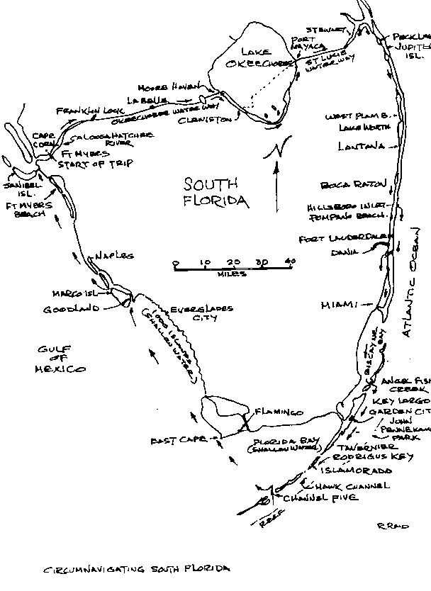
Nov. 28, 1993. Start:
Windwarrior my `79, 30 ft. C&C Mega had been purchased a couple of months before leaving for the north by car for the summer. The boat is a racer/cruiser designed for trailering so it had been made as light (4,500#) as technology allowed at that time. It was possibly the fore runner of the new ultra-light, ultra-expensive, 23 to 30 ft boats that are currently being produced. It was evident that the boat and the sails had been lightly used. It also had a 2200 lb. retractable bulb keel which gave a draft of 2 to 5 ft. The retractable keel made it a practical boat for the shallow waters of Florida and the Bahamas. This was my first chance, upon returning in November, to see how the boat would handled on a cruise.
In trying to do a macho start by sailing away from the dock I immeadiately got stuck on an oyster bed just outside the condo-not a good beginning. Later motoring into head winds and tide, on the Caloosachatcee River, marker "61" was passed at 09:50. The railway bridge east of Ft. Myers was passed at 11:45, 7.5 miles from "61", 4.7 knots average. The first lock, Franklin, was left astern at 13:18. About 3 miles past Banana Br. creek, I stopped for the night in a slight cove on the river. The boat was anchored fore and aft so it would not swing into the channel during the night.
36.5 miles
Nov. 29
Starting out at 06:48 brought me to the La Belle swing bridge 3 miles away at 07:20 . It only took about 10 minutes to get through the bridge.
Up to this point the river or canal which is a better description had been interesting. This far up the river I expect to see more modest housing, but it was not the case. I guess waterfront is water-front wherever, the houses were medium to large. A few miles past La Belle most of the housing ceased and the river was a featureless mangrove and tree lined route. However, it is wide and fairly deep up to the banks, but watch where there is a run-off from the irrigation canals which can cause a silt build-up. No alligators were seen along the way, but there is good variety of birds and fish jumping.
The Ortuna Lock was approached at 08:50 and only took 15 minutes to clear. So far I had been travelling single handed and going through the locks was a bit tricky, but they don't have a high lift.
About 5 miles past the Ortuna Lock, it was surprising to come around a bend in the river to see a large boat storage facility (Glades Boat Storage Inc.) out in the middle of nowhere. Also surprising was the number of large sailboats docked along the way, so far from good sailing. They were at houses which appeared to be their permanent home fifty miles from the Gulf of Mexico and further to the Atlantic. I went thru Lake Hicpochee at 10:32 hoping to see some alligators, but saw nothing but swamp grass.
There were two marinas at Moore Haven, I opted for the second because it was easier to get into although the first just past the bridge would have been closer to town.
After getting some gas I left Moore Haven at 12:36 and started through the rim canal, along the east shore of Lake Okeechobee. I was inside the canal at Clewiston 14:30. This was an off shoot from the main canal, thru a lock that was open, as the water level was the same on both sides. Roland Martin's Marina is just beyond the lock. It is a good facility with a store, restaurant, motel, and is home for about 100 bass boats. Lake Okeechobee is supposed to be the best bass fishing location in the world. Mr. Martin is sometimes seen on T.V., showing how easy it is to catch fish.
My crew member Steve Harmond, arrived here at about 17:30. Clewiston is a fairly large town and we did some shopping in a U Save food store there. I was definitely glad to see Steve as it is more fun and a lot easier travelling with two.
41 miles / 77.5 miles sub-total
Nov. 30
We carried on around the rim canal as I had been advised at the Marina in Moore Haven to do, due to the strong north winds. They said although it is longer it would be less time because you would not have to fight the wind and waves. There was one swing bridge to go through at Torry Island near the bottom of the lake. We could see no bridge house so we called on the radio and the bridge operator showed up in a pick-up truck. As we were calling, the radio went out. However we had a cellular phone, which was how I managed to make arrangements for Steve to join the boat.
About 5 miles south of Port Mayaca the rim canal ends and you go out into the open lake. We found the waves were not bad but I guess they were rough for a 16 ft. bass boat. Once again the lock to exit the lake was open, as the water was the same level both sides. About 4 miles up the St. Lucie Canal past the lock is a railway bridge, which is usually up, that has only 48 ft vertical clearance. While other fixed bridges on the system have 54 to 56 ft. The bridge, however, is 56 ft. wide so it is possible to heel a boat over if necessary to get through. I've heard that a dinghy filled with water at the end of the boom will do the job.
We got to Indian Town Marina at 15:05 and stayed over night. The marina was crowded, so we docked at the pumps. To get to a restaurant you had to call into town and they picked you up -not your ideal situation. Consequently we ate on the boat and used their showers.
47 / 124.5 miles
Dec. 1
We were out on the St Lucie Canal at 08:00. This area has swamp on both sides so there are few buildings. At 10:12 we went under some power cables and were getting into some housing, and later a road along side. We entered the South Fork of St Lucie River at 11:20 and some wider water. Steve had a friend up the North Fork but we carried on our planned route to get some sailing. Which we did up to St Lucie Inlet where the river meets the Intercoastal, going north and south along the east coast of Florida.
Up to this point we had used a govenment chart 11427, which has 3 sheets and also covers the west coast down to Wiggins Pass.
At the south end of Long Island the winds got flaky as we were checking out the Reed Wilderness Seashore Wildlife Refuge park, at the north end of Jupiter Island. At this point, it opens up to small Peck Lake. A couple of boats were anchored on the N.E. side, but the wind was whistling across the narrow strip of land between the lake and the Atlantic. The S.E. end is shallow, but we found an excellent anchorage just south of the lake on the east side tucked behind a small mangrove island. After anchoring there, we took the dinghy back to the lake to have a look at the ocean and explore. The waves were rolling in pretty good; they must go right across this narrow strip of land in a storm. After a stroll we returned to the boat and had dinner.
We turned in at about 20:30 ( the boat seems to give you enough exercise to encourage early retirement ), as it was raining and blowing. Suddenly there were lights flashing out outside and guys yelling. It was Steve's friend who lived at the north end of the North Fork of the St Lucie had come about fourteen miles with another fellow in an open 18' bow rider. It was quite a feat for them to find us in the dark under those conditions, hidden behind some mangroves when they only knew the general area where we were staying. They had brought us a handheld VHF to help us get through the bridges, since our radio was out. We had a little party for an hour or so before these " wild and crazy guys " departed. The boat owners father had been an offshore power boat racer and he knew the area well, which explained how well they managed under the adverse conditions. ( next chart, Waterproof # 23 )
34.5 / 159 miles
Dec. 2
We were under way at 07:35 down the intercoastal, due to the conditions outside and also there was more to see. The next inlet down, Jupiter, was also marked on the chart that local knowledge was required to navigate. However, the waterway opened up at Hobe Sound to allow some sailing, then narrowed down again at Jupiter Inlet.
At Lake Worth about 6 miles south of Jupiter we were sailing again. We passed marker "32" at 12:06. Lake Worth Inlet was useable but we were enjoying the sights on the inside.
We stayed for the night just south of Lanatana bridge on the east side, hoping to go off shore, for a change, the next day through Hillsborough Inlet.
We took the dinghy to the park at the end of the bridge and walked across into the town for dinner.
37 / 196 miles
Dec. 3
We were under way by 08:00 and passed Boynton Inlet, another one of questionable use, near the end of Lake Worth. After that there is a long stretch of canals with a few small lakes. We were at Lake Wyman marker "56" at 10:37, then Lake Boca Raton, and Boca Raton Inlet which also requires local info. At 12:40 we were outside through the Hillsboro Inlet which was no problem with the main on first reef and the 100% jib. The waves were 3 to 5 feet high and the wind was a good 15 knots.
This C&C Mega 30 is 4500 lbs which is light for a 30 ft boat. We were soon doing 7 to 8 knots on a broad reach and surfing down the waves at 9.5.
At 13:00 we passed the Surf Rider Motel, Pompamo Beach, where my wife and I used to stay when we first started coming to Florida. I never dreamed that 16 years later I would be passing offshore here in my own Florida boat.
There is a bit of a reef here so we stayed well out, but it would have been better to go inside for a view of the shore line.
At 14: 35 we were rounding a spoil area, where they dump dredgings from the channel, to go between markers "2" and "3" at the entrance to Port Everglades the harbour at Ft. Lauderdale.
Once into the harbour we turned south again down the waterway, .7 miles to a park on the east shore. We anchored the boat across from the park boat ramps and docks as far out of the channel as we could and took the dinghy over to the docks and washrooms. We were just walking over a small bridge to a snack bar when we were hailed by a park ranger. He informed us we could not stay there for the night, but recommend the Dania Cut-Off Canal.
About a mile further south, and a mile west into the canal, we found a facility operated by the Town of Dania. There is recreation building on the corner of the canal and a smaller canal going south off the main canal. Keeping to the right going in ( it's shallow to the left ) about 300 yards father, you come to ramps and docks along the canal.
We stayed there for the night free. Later we found that we could have stayed in the town marina, next entrance and had power as well as dockage for 5 or 10 dollars. However, we still had use of the showers but with a longer walk. The docks are surrounded by an extensive marine repair plaza. It was enough to make you wonder where the money came from for all the large boats.
Since it was about a mile walk into town, and we had had a long day, we ate on the boat.
39 / 235 miles
Dec. 4
We went out the canal and down the intercoastal to see the sights as there were a number of small lakes ahead and Biscayne Bay.
The number of large condos and hotels the area supports is amazing. The water is surprisingly clean, considering all the activity and buildings in the area.
We reached the Miami Harbour entrance, called Government Cut at noon. We went out to check into the Miami Beach Marina near the ocean end at 13:00. On one hand it's good choice as it is a fine facility well secured and reasonable for the area at $1.25 per ft. On the other hand it's kind of isolated.
I took the opportunity to brush off the bottom of the boat, and had a shower. Later we took a cab into town, across the MacArthur Causeway, after missing a bus. We went to the Bayside Market Place, on Biscayne Blvd, just south of the causeway. This shopping plaza is on a pier with lots of interesting shops some with Caribbean and Cuban motif, restaurants, and lunch counters. They have boat trips from here ( for some reason we didn't do that ), and free band concerts.
We bought some souvenirs for our ladies back home and had a very succulent dolphin dinner for $6. ( Not the "Flipper" variety of dolfin ). (Next chart, Waterproof #33)
33 / 268 miles
Dec. 5
At 8:17 we were at the eastern tip of Dodge Island, heading along the south shore of the Island. Then south, close along the shore of Claughton Island through Rickenbacker Causeway, and out on to wide south end of Biscayne Bay. At 10:55 we were at marker "C", well down the bay.
We wanted to go out to see the " The John Pennecamp Coral Reef State Park" on the ocean side. Looking at the charts Angel Fish Creek ( actually a pass ), seemed the best marked way to through the keys in the area of south Bisacyne Bay and Card Sound. It was none too deep approaching the creek, so we took the route of a large power boat that was coming out. This worked out Ok. At 14:50 we were at the outer markers on the ocean side.
We decided to stay there as there was no problem with wind nor waves. There was good shelter in the creek, but outside was more bug free.
29 / 297 miles
Dec. 6
About 02:00 a DEA officer show up asking if we had seen any lost Cubans. Someone had reported seeing some. Evidently, the gulf stream tends to bring them around this way in small boats or rafts.
After being assured we had seen none he departed. We left at 07:35 heading S.W. down Hawk Channel on a north wind that had conveniently come up. So far we had not seen any coral so we went into Garden Cove to get some local info. It was about 6 ft deep going in there, which looked worse in the clear water.
We left a large wreck to starboard, hoping that was the right thing to do as it wasn't clear on the chart. It is a small but friendly marina so we bought a few gallons of gas and one of their large blocks of ice. There was also a well stocked, but expensive circle K nearby.
We were advised, to find the coral, you just had to go straight out about two miles, and we would see some mooring buoys. We had heard that you could not anchor, but they said that was just in the coral, you could anchor in sand. We headed out at 135 degrees magnetic to an area on the chart that was marked 2 ft. This turned out to be just sand that we skirted but saw a standing marker further out which we found marked on the chart. There were some boats anchored nearby, and it turned out be a coral reef, about 4 miles out. ( Lat. 25 7.4' Long. 80 17.0' ). I've swum on reefs in the Bahamas and Tahiti, I found this reef to be just as good as those, although not as rugged as Tahiti, at least in this area. We had a great time swimming while Steve took some underwater photos.
After that, we carried on down Hawk Channel to anchor south of Rodrigus Key.
This areas got to be one of the best cruising grounds in the world. It is protected by the reef one side and the keys on the other. There are places to go in, marinas for service, and the great reef.
28 / 325 miles
Dec. 7
The next stop was Caloosa Marina at the south end of Lower Matecumbe Key. We decided to take a break from my cooking and have brunch there. This marina is well equipped- it has a restaurant and store as well as the usual boating gear.
Steve had to get back home so we headed through a pass with a high fixed bridge called Channel Five. By 13:05 we were at marker "X1" in Florida Bay. Again we had good winds and unbelievably small waves. Experience with Lake Erie up North which is notoriously, shallow made me wary of shallow Florida Bay. But here the extremely shallow waters to the north prevent the wave build-up by the N.E. winds.
We arrived at the East Cape, which is actually the south west tip of the Florida main land, at dusk. ( There are three points of land here, and this is the farthest east ). We came in close to shore between the East Cape and Middle Cape and immediately got attacked by vicious mosquitoes. We quickly backed off and got out the spray. As a result
of this, we decided to cancel visits to Flamingo and Everglades City.
( Next charts, Waterproof #39 & #41 )
52 / 377 miles
Dec. 8
Again we have offshore winds with not much in the way of waves, however although we are making 6 knots plus, through the water, but were only doing about 4 over the bottom due to a current that was running against us. As a result, we didn't approach Goodland at the South end of Marco Island, until dusk.
It became evident the GPS, GOTO, was giving us a bum steer as we were headed for a shallow shore in the fading light. This was probably a cross track direction. It gave us a good position on demand, however, and we headed for the outer light. By the time we got there, it was dark. We located the next light and proceeded up the channel. I had been here a few years ago and thought I could find the way. The next light after that was behind some mangroves and we went up a wrong channel, running gently aground on a soft shoal.
We got off that without much trouble and Steve who has younger eyes steered us to the light around the bend. We came into the Goodland Marina about 18:30 and it was locked up tight, however we found an open dock and used it. The restaurant, I remembered, in the marina was only open for breakfast and lunch.
Not wanting to cook we started out to look for something and found a place just over a half mile away. It was "Stan Gober's", the town and country, western singer's place in town. Steve is a fan and enjoyed talking to Stan about music and performers.
We went back to the boat with a good meal and a beer in our bellies to sleep in
quietness not experienced in years.
56 / 433 miles
Dec. 9
We were up before the Marina opened and so decided to make our own breakfast enroute. We went up the inside, behind the Island, as the winds were not up and it was shorter. There are 2, 55 ft. fixed bridges over this channel, but the channel itself is shallow. Don't use it if you have over 4 ft of draft.
Even then, keep to the outside of the bends as you would on a river. At the last bridge which you see over a small lake at marker "25", head for the red marker to the west side of the bridge, not to the centre.
We carried on past the town out of Marco Island to Capri Pass, starting to sail before clearing the pass.
We had good winds again, but this time on a close reach to North of Naples which became close hauled off Doctors Pass. This carried on to north of Wiggins Pass ( Next chart, back to Gov. #11427 ), when the winds slowed and headed us. We could have tacked offshore but we didn't want to get into Cape Coral in the dark. So we motored past Bonita Beach, Ft. Myers Beach, and Sanibel Island, into the Caloosahatchee River to Cape Coral arriving at 15:30 at my dock.
52 / 485 miles total
More time should be allowed for sight seeing, fishing etc. About three weeks would be better. This trip was more of a reconnoiter of the area. My aim to find out how the boat was for cruising was only partially accomplished as we didn't encounter any rough water. As explained at the start I only had about 4 months use of the boat. I know it is fast, ( It won an eight boat race a few days after returning ), but did not know what it would do on a long trip.
Previously it had just been down to Naples where it won a race series at the Naples Sailing and Yacht Club. However the conditions were so favorable, I didn't learn more in that regard than out on the river here. What we did find was - WHAT A GREAT AREA THIS IS TO CRUISE!
Cuban Caper
If you read my Circumnavigation of South Florida, you know that I was looking for more adventure, with my C & C Mega 30, Windwarrior. A trip to Cuba seemed like the logical next trip.
Why Cuba? Its about the size of Florida except that it runs east and west. It is the most imposing island in the Caribbean. If you go south from Florida you can't miss it. The approaches are easy with deep water in close to shore, so the navigation is simple. The facilities are good and the natives are friendly. It's a good idea to go before too many realize what they are missing and overcrowd the place spoiling the simplicity.
So the trip from Cape Coral in S.W. Florida was an opportunity to try the boat in ocean conditions without sticking my neck out too far. It was about 130 miles from Cape Coral to the Dry Tortugas, the first leg.
The start was at 10:00 hrs as we did not want to arrive in the dark. The crew consisted of Ron McLaney, who sailed with me before as part of my racing crew and Frazer Stevens, our Spanish interpreter from Toronto. We motored down the river 10 miles to the Gulf, about 5 miles out we had enough wind to sail. The winds gradually built up until we were on a broad reach at 6 knots. This enabled us to make our 10:00 hrs arrival the next morning as planned. We went into the main dock of the fortress island of Garden Key, the main island of the Dry Tortugas National Park. We had a quick look around, talked one of the park rangers, then went east a mile to anchor in the lee of Bush Key. We anchored securely with lots of chain out, as advised by the ranger, and caught up on some of our sleep. My two crew members were also getting their stomachs settled down after the trip.
The next morning we had a closer look at Fort Jefferson on Garden Key. The fort is hexagon in shape about 1000 feet (304 m) diameter with a moat around the outside. It is made mostly of about 6 million bricks. At the height of its use in 1862 it housed 2,000 people. It was built to impress the Spanish, Mexicans, and Caribbeanians with the massive structure and fire power. No one ever tried to storm the fort. Most of the cannons were gone, but they could expel red hot cannon balls several miles. They were heated to cause a fire on the ship they hit. The numerous recoil ramps of about 40 ft. were evidence of their tremendous power. Nasty stuff. During the civil war it helped to blockade New Orleans and the rest of the Gulf shore. However, it never really justified its expense, and the development of exploding shells later, made it obsolete.
It remains an interesting stopover for boaters, and the diving is good. There are no facilities there, so be prepared to use your resources.
We did some swimming and diving and intended to do more the next day, but heard that the weather was to get heavy. The harbors are not well protected, so we decided to head for Cuba that afternoon.
We soon had 30 knot north winds; the heavy weather had arrived early. We were running on the 100% jib and reefed main but there was too much yaw. I forgot to lock the main traveller and it gave me a nasty crack on the shin during an accidental jibe. We took down the main and just went on the jib which settled things down, even with the occasional 50 knot gust.
The waves soon built up to 7 ft with the odd 9 footer. The transom is open on one side so I expected water on the cockpit floor, but the stern rose beautifully on the waves so there was no problem. The wind combined with the gulf stream made the waves look like moguls on a ski hill. We left D.T. at 15:10 hrs and arrived at Cuba, 95 miles at 8:00 the next morning. We were off course about 10 miles to the east due to dodging freighters and Ron reasonably mistaking a building in Havana for the hotel at the marina. This cost a couple of hours, but we had an interesting tour of the ten miles of coast between Havana and Hemingway Marina.
I was concerned about coming into the channel at the marina due to the high waves and wind. We had to go on a close reach to approach the harbor. So we rolled up the jib and raised the reefed main. To avoid jibing, we did a 270 degree turn and headed down the channel to the marina. The channel was deep so the waves were no problem and the faithful 15 HP Evinrude started on cue.
The Cubans, I understand, usually come out to meet you but not on that day. They were watching as we came in and were impressed by the turn to come into the channel.
We came into the government dock and an amusing parade of officials started. After 5 or 6 we were escorted to our dock in the large marina.
After we were at our birth another parade of officials started again. Including my marina membership, which resulted in discounts, we ended up with 14 pieces of paper. It seems a good portion of the Cuban population is part of the government.
There was a clinic at the marina so I went to have my leg checked as it was swelling from the injury just below the knee cap all the way to the toes. Two doctors and a nurse had a look at it and a lady doctor decided since it was hot, I should have penicillin and some drops for my blood. The drops were also good for the memory of elderly people. Since I fell into that category they sounded like a good thing. The medicines, however, had to be picked up at a hospital in Havana.
The next day we hired a taxi to pick up the medication and went on to the school which had been receiving supplies through "GAM" magazine.
They did not have the tablets, as ordered at the Hospital, so they gave me penicillin shots instead plus the drops came to $50 US. I heard later this was a very reasonable price. The treatment at the clinic was free.
After that we dropped in on the school and had a very good reception. They showed us the class rooms with the small children obediently at work. Later we took pictures inside a playroom and outside the school. I had brought 1000 sheets of art paper, 2 boxes of pens and 3 dozen articles of kids clothing.
Before the trip I had considered contacting some Cubans in Cape Coral but I had heard that some had threatened sabotage to boats that were in the Tampa to Havana race last June. They said that visitors help Castro. I didn't see Castro but did see a lot of tiny smiling faces.
After the school we had a tour of Havana. We saw the exhibition of the revolution, a farmers market etc. Most of the buildings need repair and paint. However, we found that not everyone was unhappy, but were unable to tell the happy to unhappy proportions.
The driver had originally asked for $10. But we felt that for the amount of time and distance that $30 fair. We arranged for him to come back in 2 days. He was extremely pleased, and said he had an enjoyable day.
I went back to the clinic and started a twice daily series of posterior punctures. Most of the nurses were tipped a dollar, one refused. A nurse and the Lady doctor took a liking to my tee shirts, so I gave them one each. I had mentioned tendinitis in one shoulder, hoping they would have a cure from treating cane workers. No such luck, but one of the nurses massaged the shoulder each visit as well as administering the shot in the behind each time with disposable needles.
They had advised me to stay off my leg as much as possible and to keep it elevated, so this curtailed some of my planned activities. However, I did meet some interesting characters along the docks.
There was the Spanish heiress whose family had a warehouse full of "hardware" in Havana before the revolution. When Castro took over, the hardware disappeared, so she was living on her 50 ft. ketch at the marina trying to collect the 6 million dollar value of the hardware.
There was a 26 ft Newport sailboat which had left Los Angeles almost a year ago powered with a 6 HP outboard. The captain's wife had enough of the cruise by Nicaragua and had returned to L.A. However he had picked up a female passenger in Belize. They were looking forward to returning to the US at Key West.
Then there was a spry 75 year old ex US airforce pilot who had toured the Caribbean by plane during the war and was now doing it by boat. He was about to marry a Cuban girl.
Most of the boats at the marina were US, but there was good representation from Europe.
Bob Wright who arranged the Tampa to Havana race in June had stayed there permanently after the race. They were in the process of building condos and there was to be another race at the end of December. Bob stopped by almost every day to chat about various plans for the marina and existing facilities.
The marina is well appointed and has lots of space, but the swimming pool with the swim up bar I had heard about was nonexistent.
After a few days relaxation, we were picked up by the taxi for a ride to a beach. To get there, we had go through Havana, then east about 20 miles. ( We eventually found out there were no good beaches in the immediate area. )
The driver located a pretty beach at Rio Jibacoa, with a creek running out where we stopped. We did some serious sunning and swimming.
At lunch time Frazer was talking to a pretty girl who had a four year old boy with her. We invited them, and the taxi driver to have lunch with us. It turned out she was an underemployed metallurgist. It was not unusual to run into well educated Cubans.
Also, you will never see more beautiful bodies in one place. The skimpy diet doesn't seem to hurt the appearance of the population.
On the way home through the countryside we were stopped by a policeman for a check. He was more interested in the cab driver, who apparently was missing a license of some kind, so the police officer took his license plates but allowed him to drive us back to the marina.
The next day a Mexican boat came in with its mast laying along the deck. I asked the captain if that happened Wednesday. He said, " Yes, how did you know ?"
I replied, " Because we were also out there that day."
They were off the west coast of Cuba and got caught with too much sail up. The shrouds and stays gave way and the mast went overboard. They immediately anchored that night and the next day scuba dived miraculously locating the mast in 20 ft. of water. It had survived the ordeal without bending.
One or two boats a day were coming or going and they all had something of interest to tell. There were about 40 boats in the marina which was a small fraction of its capacity.
Frazer did a walking tour, 10 miles into Havana and back, plus about 5 around the town.
We decided to explore a cove 4.5 miles to the west called Playa Baracoda, requiring another form for cruising. We went along to the cove as Playa usually means beach, but there was no beach of any account. Also we tried to do some fishing, but did no catching. We called over a local fisherman who was using two inner tubes held to-gether with a wooden frame. This also gave him a place to mount oars. (This is a common rig in Cuba.) We wanted to see what he was using because we were having no luck. He was just using a hook and chopped up small fish. We gave him a large can of pork and beans and some hooks. He was one of the Cubans that wasn't happy, even though he had caught some fish including a large barracuda.
The prices in Cuba seem to be all over the place. For example, .50 c for a post card but only $5 for a tee shirt. Local beer was $1 a can but Heiniken was .70 c . The restaurant meals were mediocre, skimpy, and pricy for what you got, consequently we mostly ate our own food.
One of the customs fellows was particularly friendly so I asked him if his wife would do a Cuban meal for us, using a large canned ham we had, as the restaurant fare was not representative. It turned out he was living with his mother-in-law who was looking after her sick mother, so they couldn't do it. However that night, he brought us a plate of food to the boat. There was rice with black beans, potatoes like limp french fries, and a large lump of pork. The vegetables were good but the pork was more than 90% fat.
Next day we thanked him by giving him shampoo and bath soap for his wife, candy bars for his daughter and a can of our lean corned beef.
We had planned to go 60 miles along the coast to Veradera, a beach and resort area but didn't do it because of my leg injury.
After a week, we started checking the weather reports for our return. We got a report of S.E. winds 10 knots so decided to head for Key West. I went to get my last shot, but the clinic was closed down. Someone told me it was moved over two canals, but it could not be found around there either. We stopped at the government dock and had to wait 45 minutes for some official to show up. When he did, we got another piece of paper and had a friendly good-bye.
The winds looked strong and not in the direction forecast, so we put on the storm jib. When we got well out, the winds increased 25 to 30 knots N. W. which mandated another reef in the main. We were facing another erroneous weather forecast. The boat was moving real well on a close reach, which calculated out to 14 hrs for the 90 miles to Key West.
As we approached Key West, this turned into close hauled and finally we were headed about 20 miles out. Trying the motor under these conditions only resulted in 2 or 3 knots on course. Under good conditions the 15 HP can push the boat up to 10 knots. So we started long tacks 2 hours to the north and 45 minutes east. The clouds were building up and about 10 miles out from K.W., we ran through 3 small squalls. The result was a 17 hour trip instead of the 14 estimated at the beginning.
The crew was sick off and on so the second hand was the autohelm. It gave me a break, sometimes under adverse conditions, when the crew couldn't.
We anchored off an island near the town of Key West to get sorted out and relax for a while. I discovered that one of the reefing points had been tightened too much causing the main to rip. Amazingly it only ripped near the eye where it was tied, and held together in the high winds.
Ron and Frazer went into K. W. later in the dinghy to phone home, reporting our safe arrival.
The next morning we went into A&B marina and contacted the officials. We found out later that it should have been done immediately. The agricultural officials showed up promptly but the customs/immigration fellows who said they were on their way never came.
Ron was heading home from this point and John Barth who was driven down by Ron's wife Beverly, took Ron's place.
We all had a nice lunch at A&B. Afterwards, we did a walking tour of Key West. I had the main repaired at a sail maker near A&B. It was expensive but quick and well done.
We were considering a return by Hawk Channel or a direct shot across the bottom of Florida Bay. The winds dictated the Florida Bay route.
The next morning we started out leaving the outer K. W. marker # 1 astern at 08:57 hrs. We were headed N. W. for the Little Shark River area, near the south west tip of Florida. The relatively smooth water was a pleasant change from the lumpy gulf stream.
There was a slight leak in the boat, caused by the pounding coming into Key West. After a lot of speculation and searching it was determined that it was coming from the stern. The hull extends past the transom 3 inches. There was some crazing on the joint between the transom and the hull which was the source. Fortunately this was easy to repair because when the boat is light, it is out of the water.
We gradually got headed and had to fall off, then motored 4 miles east to 1 mile offshore. We anchored there as the wind was offshore and we were at the bug's paradise, the Everglades.
The next morning we headed up the coast to Goodland, Marco Island on 15 to 20 knots wind offshore and 18 inch waves. It doesn't get much better than that. We went around the north end of town to anchor across the channel from Stan Gobers restaurant, which was in a small bay.
After getting cleaned up, we rowed the quarter mile in the dinghy to Stan's. He had tables inside and out under tiki huts. Luckily, we opted for the tables inside because it began to rain hard. We had a first class dinner with all the trimmings and wine, for $10 each. We left the waitress a good tip and sat around waiting for the rain to end. The people outside were getting very damp and gradually departing. We were among the last when Stan made us rain coats for John and I out of large plastic garbage bags. Frazer was taking a bath, clothes on, under a rain spout. At the dock, we found the dinghy filled with water within 4 "of the gunnel. Frazer, laughing, jumped in the water feet first not knowing where the bottom was, to bail out the dinghy. Fortunately it was soft bottom 3 feet deep. Three men in a boat, I rowed back to the Windwarrior. The rain gauge onboard showed we had 4" of rain in 2 hours.
The next day was the final run back to Cape Coral. The wind was not favorable so we had to motor. Going up the Calosahatchee River home, we were able to finish the last 6 miles in style under sail.
This trip was too rough on the boat, but I will never forget the terrific job it did tearing up and down those 6 to 9 ft mogul type waves in the gulf stream at 7 knots. It was exciting without being life threatening. Another great thing was that we never heard a word about O. J. for two weeks.
If going back to Cuba, I would go to Veradera, because I like beaches, although there may be more variety around Havana.
Trip date Nov. 21 to Dec.5, 1994
Cruising the Bahams with Mr. Claus in a boat called Mary Christmas
A month before heading north to our Wasaga Beach home from the Florida condo in Cape Coral, the opportunity came up for a Bahamas trip in a 32 ft. Irwin sloop.
I had decided that my 30 C&C Mega was light for this kind of trip ( See Cuban Caper ), therefore a safer trip was expected from the Irwin.
Paul Claus, owner of the Irwin had crewed for me on the Mega during two races in Charlotte Harbor regatta, where we won a first and a forth due to a wrong turn we made in the second race. This broke a two year winning streak of first place overall. Paul has white hair and a beard to match so he does look a bit like Santa Claus. However, both his waist line and beard are smaller than the jolly old elf is usually depicted, but he does get some mileage out of the similarity. It helps him meet people, which he finds enjoyable.
Before leaving, one job we had to do on the Irwin, was to replace the swing keel that had fallen off. This had taken longer than expected, so we had only gotten a short run rather than the sea trials we had planned. The sixties vintage boat had been used mostly as a day sailor both by Paul, who owned it for the past two years, and the previous owner. Consequently, it had light use and was basically in good condition .
We stocked the boat the day before to get an early start the next day for crossing the 126 miles of Okeechobee waterway from the west to the east side of Florida.
The next day we had typical Florida weather for April, sunny but not too hot. Soon we were past the Cape Coral/Ft. Myers section of the Caloosahatchee River against head winds that were typical for most of the trip.
This was my second trip through this waterway so some of the novelty had worn off, but there is a mixture of good homes and tree lined banks that create an interesting change of scenery. The locks are low lift and easy to traverse. The first night we stayed near a trailer camp just past the town of La Belle.
The next day we stopped at Moorehaven for gas and later that afternoon crossed Lake Okeechobee. We stopped for the night on the east side of the lake, just before the railway past Port Mayaca. The bridge is notorious as it has 49 ft clearance, whereas the other bridges are 54 to 56 ft., depending on the tide. It is wide enough to lean a boat over 45 degrees which allows almost 70 ft. of mast height.
That evening while checking to find out why the batteries were not charging, we found the generator belt had broken, luckily Paul had a spare that was a bit long, but it worked.
From Mayaca we travelled past Stuart to the east side at Port Salerno and went into a long narrow cove called, Manatee Pocket. We headed for a marina aptly called, Pirates Cove, due to the $1.25 per ft. dockage with a minimum of 35 ft., and a $5 dollars charge for electric hook-up. However, we did have a good hot shower. During the run in there we bumped bottom a couple of times despite our relatively shallow 3 ft. 9 inch draft. It would have been better to have anchored off the park, which was on the north side of the entrance, located closer to shopping.
The next day we travelled about 30 miles down the intercoastal to Lake Worth at Palm Beach. This is a regular departure point to get a better angle for the crossing to the port of West End, in the northern Bahamas. Also the St. Lucie inlet near Stuart is shallow and subject to change. Many of the inlets between the intercoastal and the Atlantic have the same problem.
We were waiting for a weather window, so we decided to leave at 20:00 hours to arrive in daylight. As it turned out, it took 21 hours to cross the 58 miles to West End. So it was a good thing we did not leave at 05: 00 the next morning as originally planned. We could have sailed the first few hours, but Paul elected to motor. The course was about 100 degrees, but in the Gulf Stream we had steer 140 to 150 to maintain course. For a sailboat, it would be better to cross over from Ft. Lauderdale, so you don't have to fight the stream as hard. From the west coast going south through the keys at Channel 5, then north to Ft. Lauderdale, should result in more sailing. Part of the problem is the winds are more often than not from the N.E. Strong winds against the 3 knot north flowing Stream, results in very choppy rough seas. Therefore a west to south-east wind is desirable.
Our winds were south east but gradually backed to easterly. The winds were forecasted 10 knots, but soon picked up to 20, waves were 5-6 ft during midcourse. The trip was quite tolerable, but the average speed of 2 3/4 knots was frustrating at times. Once we got a GPS (Ground Positioning System) reading of -1 knot while over compensating for the Stream.
The approach to West End is easy. You see the antenna and the water tower first, soon the end of the island and the cays ( pronounced keys ) to the N.E. are visible. We were told that you had to check in with customs at the commercial dock, which is up a channel just south of the island tip. There was no activity, nor boats there, so we turned around and made our way into Jack Tar Marina.
Even though it was 18:00 hrs., we expected to be met by attendants in white coats and black pants. However, the marina was deserted except for a few cruisers like ourselves. The facilities were run down but still useable. We went into a dock and found ourselves in front of the missing customs office. We heard that it was advisable to check in with customs immediately, but we couldn't find a phone number.
There was no problem the next day reporting in when the customs people showed up. We were charged extra as it was Sunday, but this just came to $75 for both of us, including a fishing license. We were now free to wander and see the sights.
The first thing at hand was to see the town of West End, which was about 2 miles away. We started walking, when a young local man offered to give us a ride. He refused any payment, which was our first of many pleasant experiences with these friendly people. There were just a few small stores, hotels, restaurants, along the water front. Conch was obviously the main diet,as there were large piles every several 100 ft along the water front. We had soon seen the little that there was to see, so we stopped for a cold beer at the local pub and to have a drink with O.J. Not the one you know, but a local real estate type. We found out from him and others, that the marina was once owned by Charles Salmon, a Texas oil tycoon who died, leaving it to his wife. His wife did not have much interest in it and this coupled with some labour disputes, led to its demise. The story concludes, that the marina, 27 hole golf course, a few ransacked hotels, an airport along with 2700 acres that it stands on, were sold 2 years ago for 9 million dollars. Plans are supposedly underway to rebuild the place. -They live in hope!
We had dinner of conch, naturally, in a recommended restraurant, typically small, called Yvon's. The food was good, the price reasonable, and the hospitality outstanding. After dinner, Frank, Yvon's English husband, drove us back to the boat.
Don't plan on using West End as a source of supply. We had a problem trying to buy a book of matches. Beer is expensive in the Bahamas, liquor is reasonable. If you can, bring all the groceries you will need. The small restaurants are reasonable but have a limited menu. The standard price seems to be $7 an entree.
The next day we decided to take the 25 mile bus ride into Freeport. The bus left us at the Princess Hotel, where Paul had stayed some years ago. There was a so called "International Bazaar" alongside the hotel. The international flavor was a few oriental restaurants. We wanted to see more of the "real" town, so we took another bus from there. Downtown Freeport turned out to be a small shopping mall, anchored by a Florida Winn Dixie grocery store. At least we were able to buy an egg lifter, which Paul had forgot to bring for the boat and was unavailable in West End.
After getting over our reverse culture shock, we decided to go to Lucaya Marina, which had been suggested. It is very touristy, but you can pick up some souvenirs and get a good meal.
Upon our return we talked to some of our neighbours. Will and Elaine on "Cygnas", from California, who have an interesting 34 ft. pointed stern sail boat that had been made in Taiwan. Elaine told us about an adventure they had in a storm. Will collapsed at the wheel after 36 hours, she then moved him to the cabin floor, where he slept for the next 18 hours, while she took the helm and prayed while talking to the dolphins. That's sure not my idea of fun.
The next morning we did laundry in preparation to leave West End before noon.
In addition to our Florida charts for the Abacos, all that is necessary is a booklet called "The Cruising Guide to the Abaco" and Waterproof chart # 38A. If you are doing more than Grand Bahama and Abaco, I suggest "The Yachtsman's Guide to the Bahamas", plus whatever charts are required to cover the area to which you are going. The channels are marked by large black telephone pole size posts which are easy to spot.
Our first trip in Abaco was a leisurely 30 miles to Mangrove Cay. The only protection there, was to be on the leeward side of the island. However, Abaco is surrounded by reefs and islands which prevent the ocean waves from reaching the cruising grounds. Plus, the relatively shallow water, roughly 10 ft average, does not encourage the formation of large waves. It was normal to have only 2 to 3 ft waves in 20 knot winds, which is one of the reasons for the popularity of the region.
When we reached Mangrove, we decided to put out two anchors as recommended in the guide books, for reversing currents. The spare anchor was attached to some hemp line that broke when we tried to set it. After we set the main anchor, we started a search using the dinghy for the missing anchor. One of our neighbors who earlier had borrowed a cup of margarine, volunteered to be towed behind with a mask and snorkel to get a better view of the bottom. We were unable to find the anchor, despite the clear water. Later our helpful neighbour invited us over for dinner.
The boat was a 40 ft power cruiser "Somer' Magic" with a 12 ft beam, completely cluttered with nautical junk. The trim had been taken off in preparation for painting and was tied to the forward cabin top. There was a problem creating a place for us all to sit down.
The captain, Frank, from Tennessee, had been cruising with his 84 year old mother, on board for some time. They made a living, partially by fishing and supplying restaurants. Frank was a gourmet cook, so our simple meal of fish and brown rice was simply delicious.
It was interesting that both the live-a-boards, this boat and "Cygnas", had a severe problem with over crowding although the former was completely out of control. It was a lesson for all who cruise extensively; if the usefulness is at all in doubt leave it out.
The next day we had another easy jaunt to Great Sale Cay. We found anchorage in the west side bay. Afterwards we took the dinghy to the beach to the north to have a walk and explore. There were some 12" diameter sponges along the shore, but they were full of sand and bugs. Just off the beach were the remnants of some large tanks and their supports, left over from some failed enterprise. It's not easy to make a buck out there.
After our day of beaching, some fishing was the next activity in mind, so we headed for the Fish Cays, another easy 40 miles away. There was supposed to be anchorage between the middle two of the four Cays, but we found it too shallow. We got enough protection for the night about 600 ft off shore. Trolling along the south shore of the second Cay to the east in the dinghy, soon produced a couple of small barracudas, caught on a 4 inch silver repella. The older ones develop a toxin, but the young ones are Ok. They made another good fish dinner.
The following day we decided to do another 40 miles and headed for Green Turtle Cay. Shortly after our start, the 4 HP motor jumped off the stern of the dinghy. Luckily it was also tied on and dragging in the water, or it would have gone the way of the anchor.
On the way we stopped for fuel and lunch in Coopers Town. This town is only slightly larger than West End, but again nice people. Enough said.
We motored into Green Turtle in time to work on the motor, look around briefly, have dinner, and bed down for the night, east of the government dock. The next day we did a walking tour of the quaint little town. An examination of the memorial garden off the main street, and the small museum nearby, provided an interesting history of the town. Most of the money had been made in the early days through fishing and pirating. There were stores in town where you could get supplies, and restaurants where you could fill your belly. We had a good lunch for the standard $7.
This was just the start of the best part of the Abacos, but we had to turn around here to allow me to do my snow bird thing and return to the north. It would have been delightful to go on to Port Hope and Marsh Harbour.
Our next anchorage was on the south side of Hawksbill Cays, which is about a mile north of Fox Town. The shore line at Fox Town is rocky with a 3 to 4 ft. approach depth. Since the dinghy motor was acting up after its bath, we had to skip this town.
We continued our return trip next day past the Centre of the World Rock and around the shoals at the south end of Great Sale. Just in case you ever wondered, where the centre of the world was, it's out there, east of Great Sale Cay, marked by a rock.
In the meantime, I caught another barracuda, while trolling underway. We carried on past Great Sale this time and anchored off Mangrove. The next day we had a leisurely morning, working on the sink pump and oiling the 4 Hp. motor. The weather forecast was not good, but the wind was in the right direction, so we could sail, for a change. The visibility was about 1/2 mile but we had 2 GPS, onboard so we had no problem finding the large black post markers on the course to West End.
The next day we did laundry and had dinner at Yvons, with some Dutch neighbors. There was also a boat nearby, "Demdike" from Rosedale, Ontario on the Trent Waterway.
In the meantime we were watching the weather and listening to the reports. We decided to leave at 08:00, which meant getting into Ft. Pierce at night. Two other boats that were going to cross decided to wait until later.
Ft. Pierce was selected because it has a good inlet and the course is 340 degrees magnetic, so you get help from the north flowing Gulf Stream. As a result, we did the 82 miles in 16 hrs in comparison to 21 hrs for 58 miles on the trip over. The winds were also more favorable, but reached up to 25 knots, again with 10 knots forecast. The seas built up to 5 to 7 feet.
Ft. Pierce at 24:00 hrs. did present a confusing array of lights, but following the GPS course to the first channel marker finally got things sorted out after a few anxious moments. We found an anchorage near the first range marker out of the channel.
The next morning we were concerned about our colleagues who decided to cross later, as we had winds of 25 knots on the intercoastal which were probably 40 knots out in the Gulf Stream.
Another incident occurred while waiting for a bridge to open, Paul did an accidental jibe and took out the back stay. We had some anxious moments while I got a halyard back, and later lashed the stay.
I had visions of another dismasting like the one that I was involved with on Georgian Bay during a race.
To our surprise, when we got to the St. Lucie Lock, to anchor for the night, we found Frank's boat, "Somer' Magic", docked nearby at a small park. We had been told by the lock master that the only eatery nearby was a Dominos Pizza, which would deliver, so we thought we should invite Frank and his mother to have pizza. However Frank was off somewhere picking up mail and seeing his girl friend. Mother already had dinner. He had taken the engine of the 16 ft runabout, that he towed behind, apart and the crank shaft was lying rusted on the swim platform. Frank showed up some time after we had finished our pizza. His main problems were his computer printer not working, a bent prop shaft, and the runabout motor which he said was shot any way; listed according to Frank's order of urgency.
The next day we laid over while Paul adjusted the valves on the diesel and I took the 4 HP apart, to lubricate the starter cord return mechanism, which was sticking. After our efforts, both motors ran well.
We also found while improving the jury rig on the back stay, that the chain plate, that attached the stay to the boat, had been cracked for some time. So it was fortunate we motored most of this trip or the back stay may have let loose in the middle of the Gulf Stream. We never used the swing keel we had replaced before leaving. Maybe Santa's elves were looking after us.
Two days later we were back at Cape Coral, having covered 642 miles in 19 days; a short but great sampling of Abaco and the Bahamas. It just gave us a taste for more.
July 8, 1996.
Virgin Island Venture
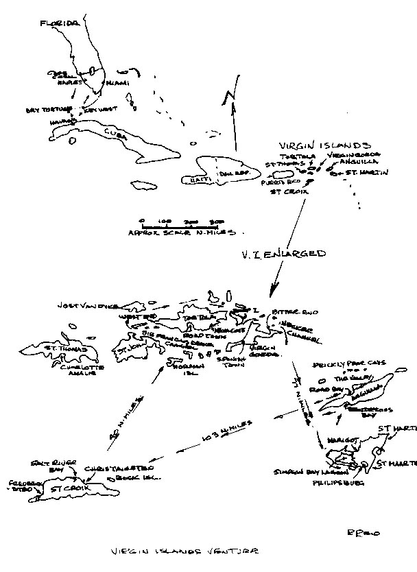
One of the great things about sailing is the likable people you meet. As a result of meeting Al and Lois Woolnough in Collingwood and crewing for them at the Collingwood Yacht Club, I subsequently met John and Beverly Blais and, then, through them, got involved in the Georgian Bay Sailing Association.
Besides crewing for John on the Tuesday night races in Collingwood, I've had a number of pleasant trips on his boat.
As a result of sailing in Florida, and joining the Cape Coral Sailing Club, which is really a great club, I've gotten to know more people there than in my home town of Wasaga Beach.
When John decided to cruise the Lake Huron, North Channel I crewed for Frank Murphy in the Georgian Bay Regatta, and the following year for John Otton, who both have a C&C Mega 30's like mine in Florida. Some years previous Glen Lowes was kind enough to give me a berth.
Another crew member with John Otton was Erik Erickson. He has a 50 ft. Gulfstar sloop, in Tortola B.W.I., called Bamsen I. We got along well, so Erick asked me to go down to sail on his boat. It was a lot easier, cheaper, faster, and safer to fly from Florida to Tortola than to sail there in my 30 ft. boat. So I jumped at the chance. Also, since my wife Josephine does not like sailing, I didn't want to leave her alone too long.
It turned out the easiest way to get to Tortola from Cape Coral was to drive to Naples, where they had free parking, and fly from there to Miami, and then Miami to St. Thomas. I was to meet Erick and his friend Brian Turner at the St. Thomas airport, but they weren't there. After checking for messages, I took a cab to the ferry for the short ride to Tortola. At the ferry, they almost put me on the wrong boat. Just before the boat left the dock, Erick and Brian jumped on board, and aborted a trip that could have led to a set of strange and confusing events.
Their plane had been delayed and they had sent a message to me, but the airport people ignored or lost it. This happy encounter relieved the concern of trying to find the boat and wondering what happened to them.
We soon had the first sight of the dark green hilly islands against the vivid blue waters, with the sunny warm climate moderated by a strong breeze; prefect conditions for sailing. In most boating areas up north, power boats were in the largest numbers, here, sail boats far outnumbered the power boats.
We stopped at West End, Tortola, went through customs, then carried on to Road Town through the famous Sir Francais Drake Channel. I had brought some groceries with me which included some ready made packaged meals and, a tentative grocery list for the rest.
There were a couple of fairly good grocery stores in Road Town. One was a semi-wholesale store which sold larger quantities that were good for stocking a boat. We picked up some things on the way to the boat, then carried on to where the boat was docked at Maya Cove.
We spent the next day getting the boat ready. The mast head anchor light was' out, so yours truly was selected to go up the mast. Sails had to be bent on, lines fastened, etc. The main problem was the refrigerator, which would run off shore power, but not through the inverter which converts battery power to 110 volt AC.
This came about because the boat was rented out a few years ago. The fellow who was looking after the boat, loaned the dinghy to another boat he had on rental and the fellow crashed them both on a rocky windward shore. Erick decided to take the boat out of rental after that and moved it to Tropic Island Yacht Management, where it is now. The fellow where he had it previously sent him a bill for $800. While it had been left to Erick to pay $5,000 to replace the floors that had been ruined by people coming in from swimming then standing around in wet bathing suits dripping salt water. This also included the replacement of counter and table tops, that had been cut-up. The fellow kept sending larger bills until they got to $5,400. at which point the boat was seized. Erick hired a lawyer and had to put $5,400 in trust to get the boat released. Getting back to the inverter, just before this happened the inverter was removed for repair. He eventually found the reason it worked before but not now was that it was a different inverter.
In order to get the inverter problem sorted out, we moved the boat to Road Town, which also enabled us to complete stocking our provisions.
The electrical contractor blamed the yacht management, which we believe had nothing to do with the inverter. The short of it is the problem never got resolved despite the heavier wiring that was installed. This was doubly frustrating as Erick had just purchased a couple large batteries to replace two of the existing ones. The yacht has 3 batteries and 3 alternators.
An interesting caution here to those who think it sounds like a good deal to have a group rent out and look after your boat. These boats are in use night and day, most of the year around. As a result, they get about 15 years wear in 4 years, at which time the rental company usually no longer wants them in their fleet.
Erick's boat had originally been built for rental, consequently it has a minimum number of sails and sail controls. The mast is short for the length of the boat making it slow but stable. It is a very comfortable boat for living onboard. The cooler we were having the problem with, consists of three connected compartments about 6'x 2 1/2x 3 1/2' deep, with a freezer in the middle compartment. It worked great on shore power. The yacht has three sleeping compartments, the rear masters cabin was divided from the forward cabin by the centre cockpit. The engine room under the cockpit is about 8'x8'. Brian had the forward vee berth. I had a bedroom off the galley that has bunk beds, that I just used as a dressing room, opting to sleep in the main cabin, which had a larger bunk. With just 3 onboard this yacht, we had lots of space. We purchased about 60 lbs of ice and were on our way.
We soon sorted out our jobs, mine was navigator-cook. Brian was strong hand and galley assistant. Erick was the best helmsman, who also had good knowledge of the area.
We had three GPS onboard. I had brought my own and had picked up one for Erick in Florida. Brian is a surveyor, consequently he had his along as well. We were somewhat confident that we always knew where we were.
On our third day, we started our trip sailing into Spanish Town, Virgin Gorda for water, which was 10c a gallon compared to 15c in Tortola. From there we went to Bitter End, Virgin Gorda, to anchor out. This was a 19 mile trip from Road Town.
That night, we went to the famous Pirates Pub, on Saga Rock, off Bitter End, but the bearded owner was elsewhere. We heard that it had been sold and the new owners were expected to take over shortly. He had been hired by the government to look for wrecks some time ago. He had found about 45 and some had treasure, which was turned over as required, but after the adventure, were told he had enough to buy a couple of islands and build the pub.
The next day we took a water taxi to Gun Creek, and a land taxi back to Spanish Town, to check into the customs office, which was closed when we were there the previous day. That afternoon back at Bitter End, we toured the town, which was mostly expensive resort establishments but very clean and beautifully done.
Later on, while we still had daylight, we started the 77 mile trip to Phillipsburg, Sint Maarten, from Necker Island Channel east of Virgin Gorda to arrive the next morning in daylight.
Going from here rather than Tortola, gave us a better angle for sailing and shortened the trip about 12 miles. We were able to sail most of the night. The only excitement ocurred during Brian's turn at the helm, a large flying fish brushed past him and landed on the deck. He managed to get hold of it after the initial shock and toss it back.
The yacht was great to steer, as it tracked very well through the 6 to 7 ft waves. You could go as long as 10 minutes without moving the wheel. Erick was very adept at sitting on the bench behind the wheel and steering with his toes. The boat's name, "Bamsen", means teddy bear in Danish, an accurate description of this comfortable kindly boat. We saw no other boats during the night, but in the early morning we came across 2 cruise ships and a freighter also headed for Phillipsburg.
We got a bit south of our course, due to the east winds, so we decided to motor sail about 12 miles out. The only problem was the motor started to act up, so we positioned where we could sail into Phillipsburg if necessary. Between this and dodging the other boats just mentioned, we lost an hour or so.
Sailing into Phillipsburg was no problem. The motor obligingly started when we wanted to anchor on the west side of town, near the beach. The first order of business was to get caught up on some sleep, which we did immediately.
Later, we took the dinghy to the ferry dock that was used by boats taking people off the cruise ships, so we could go to customs and immigration.
After customs, we did a walking tour of Phillipsburg and looked for a new tachometer for the engine. Later, we looked around for some place to eat. At most restaurants, entrees were $20 with $10 for appetizers, however, we located one a few doors west of the dock called,"The American Bar", which had good food at about half the price of the others.
The next day, Erick located a mechanic to look at the engine and install the tach. Changed filters cured the engine problem, but the tach still do not work, as the problem was with the sensor.
It may seem we were dealing with a lot of problems, but this was not the case, as we were enjoying the trip and had good meals, usually proceeded by a happy hour.
The next afternoon we moved to Simpsons Bay Lagoon, which is a large lagoon accessed through a lift bridge at Port de Plaisance.
This is very well protected, although not very deep. A considerable number of boats had anchored there during the last hurricane and sustained much damage despite the enclosed lagoon. They were littered along the shore, where they had either been driven by the storm or, moved later to get them out of the water. We heard that it had been a real nightmare, due to boats dragging anchors and smashing into other boats.
The border between Saint Martin, the French side, and Sint Maarten the Dutch side, runs through the lagoon. Since we saw traffic freely running back and forth along a road to Marigot, on the French side, we did the same with the dinghy. We toured around Marigot and tried to get clearance for Anquilla, where we were going next, but this could not be done. We had terrific crab sandwich on a fresh baked bun for lunch in a small water side French restaurant, called La Croissanteria.
When we returned, we found the yacht had been put on a mooring by our neighbors, to rescue it from the same fate as hurricane wrecked boats. The wind had been blowing a good 25 knots. We believe our CQR anchor had dragged a couple of times before, because the joint was worn between the blade and shank. So Erick and Brian went off to get another anchor and more ice in Port de Plaisance, while I watched the yacht.
The next day we left S.B.L. at the 11:00 hrs. bridge opening, heading for Rendezvous Bay, Anguilla island. This has a beautiful crescent beach, but we found out the next day, boats are not supposed to anchor there. We had in the first swim of the trip with a walk along the beach.
Since the boats were dumping overboard, there is no inducement to swim in anchorages. This definitely needs to be changed.
The next day we had a leisurely trip around the west end of the island to Road Bay, tacking on the north side of the island, against the N.E. winds.
We checked into customs/immigration, which was right at the end of the dinghy dock.
Anguilla is a laid back island which is not interested in attracting the large tourist ships. The main town is The Valley, which is located about 4 miles east of Road Bay and has a fairly good IGA food store. Road Bay's main claim to fame is that it has a freighter dock, which can be approached, if they are not too heavily loaded and the ocean wave surge is not bad.
North of Road bay is Sandy Island, which has a bar, and further out the Prickly Pear Cays, which is one of the best snorkeling spots in the Caribbean. We headed out to the Prickly Pear Cays after paying a small fee for the privilege. We anchored the yacht on a mooring on the south side of the island as advised and took the dinghy to north side between the reefs and the island. The reefs were hard to reach from shore as we could not anchor the dinghy near them. I was able to swim out and explore the nearest reef, which was excellent, with lots of fish and the tallest tree like coral that I have seen.
Back at Road Bay the next day, in order to tour the island, we rented a car, which is inexpensive, especially divided amongst three. Touring around, we found that it has some elaborate, expensive, condo complexes which contrast sharply with the homes of the natives. Some of these had also been damaged by the last hurricane. We had dinner at Great House, which was on Rendezvous Bay, where we anchored the first night. It is one of the less expensive resorts with winter rates $185 to $440 a day.
The next day we were able to take the car back and get more ice for our trip to St. Croix. We left at 13:40 hrs for our 100 mile trip. We anchored off the end of King Cross Street at Christiansted, 11:30 hrs the next day. The trip had been easier than Necker Channel to St. Maarten. The normal 15 to 25 knot winds had been changed by Tropical storm Marco, about 200 miles west of us, to about 10 knots S.E. with correspondingly smaller waves.
Customs was near the dock in Gallows Bay, where we first came in, but the anchorage was better on the west side of Protestant Cay, where we were, so we had a dinghy ride back to customs. After customs, we looked around town and headed back to the boat, in the rain. Rain that night dampened further explorations, but it gave us a chance to get caught up on our sleep.
The next day we rented a car and headed up the N.E. coast. The hills combined with the shore line and the water, made beautiful scenery. After a while we started looking for some place to have lunch. At this time of year, November, a number of the places were closed, but we ran across the St. Croix Yacht Club in Togue Bay, south of Buck Island. We ventured in and were given a pleasant greeting by the Commodore and Vise-Commodore who just happened to be there. We had a good lunch and looked at their spanking new docks. They invited us to move our boat there, but one would need transportation to make use of these, as they were in an isolated location.
From there we made we made our way along the south coast and on to route 66, their divided highway. On the way to Fredriksted we stopped at the Cruzan Rum company, to tour their facility. They make an excellent rum, which can be purchased, in the islands, for $4.50 for 1 1/2 liters.
Fredriksted is smaller with not as many good stores as Christiansted, but it has deeper water and a dock to accommodate the cruise ships, so they go in there.
By this time it was starting to get dark, so we returned to the yacht. We were able to park the car near the rental agency, that was a short distance from where the dinghy was docked at Big Breads restaurant and bar. In return for the dinghy docking privalege we felt obliged to have dinner there. It turned out to be an enjoyable meal on a balcony over looking the the harbor.
The next day we still had some time left to use the car, so we went up the north west coast. In doing so, we came across Salt Bay Marina. Besides the usual marina facilities, they specialized in building large catamarans. Their price was a fraction of what I've seen advertised for similar sized boats in magazines. They were working on an 80 ft boat with rotating mast and repairing a large motor cat they had built previously, that had gotten into trouble. Some of the workers had bare feet. I guess "workman's comp." was no problem here.
After Salt Bay, we drove through the rain forest in the rain, then into the hills, as the rain cleared. We had a great view from Mt. Stewart when we walked up a 4 wheel drive trail, with the sea to the north, and Mt. Pellier and a housing development to the south. After returning the car, we toured the nearby Fort. Christianvaern.
The next day it was time for us to start heading back. We returned via Norman Island which is a small island, with a good cove, just off the S.W. end of Sir Francais Drake Channel. We had left at 09:00 and completed the 38 miles in 6 hours. There is a reef and some caves off the south end of the cove, where we stopped to do some snorkeling. However, the surge was very strong, so we carried on into the cove after a short swim.
We returned to the reef by dinghy the next day, as the surge had reduced, clearing up the water. It was still a little dicey to go into the caves, but the reef and the fish were interesting.
Another day, another island. This time it was Jost Van Dyke, 13 miles from Norman I., N. E. of Tortola. The island was home for another famous watering hole, Foxies Bar, in Great Harbour. Once again when we visited the bar that evening, we found the notable owner was in other parts.
After another leisurely trip, the next day we stopped at Great Camanoe Island to have lunch onboard, later, going on to Beef Island to anchor out at the east end of Tortola.
Our food was starting to get short, but we had eaten well. Fresh steak was obtained from the local markets. Erick had brought a bread machine along that worked intermittently off the inverter. Ekick also supplied canned smoked oysters, that we had for hors d'oeuvres most days. We had salad everyday and fresh fruit every morning. I made a pizza using hot sauce and canned corned beef as a replacement for pepperoni. It turned out to be very edible. When fresh food was short, we used Dinty Moore dinners. Erick and Brian suggested that we export Dinty Moores to the Virgins, in exchange for imported Cruzan rum. We did not find very much fresh fish available, which was surprising.
Our last trip was only about 5 miles back to Maya Cove, decommission the boat, to prepare for our trip back the following day.
We had a good trip back through the channel, in beautiful weather, sitting on the top deck of the ferry.
We had a few hours at Charlotte Amalie, St Thomas, before we left, and time for lunch at a harbour side restaurant. While walking around later, I was surprised to see the brigantine, Fair Jean, at dock side.
The last time I had seen it, was at Meaford during the The Georgian Bay Regatta, in `94, which corresponded with the Tall Ships' visit. It was interesting also to read an account of it in Oct.`96 GAM magazine.
Everyone returned safely home after a great, memorable trip.
Results of the court case regarding the claim by the boat
Rental agent:
Erik went back down for the trial about the boat in the spring of `97. The plaintiff did not show up for the trial, however his lawyer was there. The plaintiff's lawyer ask for an adjournment because he could not find his client. The judge ruled that the trial should proceed so that the matter could be settled.
Erik had counter sued for the damage to the boat, the destroyed dinghy, and lost income because the plaintiff did not fulfill the rental contract.
The outcome of the trial resulted in an award to Erik of $56,000. and return of the $5,400 he had put in trust for the compliant. Although British justice prevailed, since the rental agent could not be found the award was hollow. Erik's lawyer charged $5,000 so the only financial winners were the lawyers.
How you can do it.
My experience started with over 20 years as a power boater on the great lakes where I cruised over 8000 miles on my own boat. Then having realized my mistake, I switched to sail 16 years ago. I have found it to be far more interesting, enjoyable and challenging. I have taken most of the Power and Sail Squadron courses, ( In U. S. A., the U S Power Squadrons ) plus I have read numerous boating books.
What follows, is my opinion on what the minimum of equipment and knowledge, you would need to do the kind of sailing described in the previous chapters.
The type of sailing which is my preference, is to sail a day or two then spend a night at anchor or in port. It is this limited off shore and coastal sailing that is explained here. I have no desire to sail far off shore where you may have to accept whatever weather comes your way, with the possibility of winds reaching Beaufort 10 (48 to 55 knots), with 30 ft. waves. For shorter distances, you can pick your time according to the weather, however, be careful of wind forecasts, as they are often inaccurate.
From Florida, this limited off shore sailing will take you all around the Gulf, the Bahamas and Cuba as told in these stories, and even further hopping from island to island.
You can do this by sailing overnight with a maximum trip of about 120 miles, planning to arrive at your destination before noon. This gives you plenty of time to find your way into a strange port where you may have clear customs, and decide where you want to anchor or dock . It is not unusual for a few hours to be spent for that procedure even without customs. Arriving at night can result in a confusing array of lights. In some towns, red seems to be the favorite color. It is also easier to look for shoals and see water depth in daylight.
As far as running into other boats at night, the large ones are lit up like Christmas trees. Floating debris, you probably won't see in choppy water day or night.
The first question is how much do you need to know?
I've sailed with, or have had crew, with mostly classroom or book learning, and alternately boating experience with no studies, and can say both cases are bad.
For example, a fellow with 6 years of Power and Sail Squadron courses had forgotten how to anchor. Each year he had forgotten some of what had gone on the year before.
Another who had as many years doing monkey see, monkey do, which resulted in practically no knowledge of chart reading, piloting and a poor knowledge of sail trimming.
Therefore it is very important to both learn and practise what you learn. Power Squadron Basic Boating course is the minimum class room learning required. Learn this course very well, and do extra plotting. Also, the weather course is an asset, or read and study a boating weather book.
For practise, look at a chart, then look at the corresponding shore line, islands, channel marks and, land features. From a small boat you can see about 3 1/2 miles to the horizon. Note the scale of the chart and how it relates to what you are seeing. The object is to get used to the relationship between what the eyes see on the charts, in comparison to what they see on the water. This is important because there aren't markers everywhere you want to go and you should not trust navigation markers 100 % . Floating markers can drift out of place. Fixed markers can be moved or destroyed. These things seem to be changing on the charts all the time, but the rocks and islands don't move. The objective is to know where you are all the time. If you don't, you may be heading for a rocky shoal.
In addition to this there are some books you should read and/or study. One of the most notable is,"The American Practical Navigator", by Bowditch who was the Einstein of the nautical world. You could, by using this two volume set, go from grade 8 education to everything you would need to know to navigate a boat around the world. Another good book especially on small boat handling, is "Chapman's Piloting, Seamanship & Small Boat Handling".
You should get these books from the library to read and decide if you want to buy them. However, you are not going to remember all that's in these large volumes, so I'm recommending two books you should buy, read, study and, remember.
They are,"Invitation to Sailing", by Alan Brown, published by Simon and Schuster, which will give you basic sailing knowledge and includes exercises: Do them. Knowing this you can go out and find a racing boat to crew on. The reason for a racing boat is there are some cruising sailors who are happy if the boat is moving, and either don't know, or care, to get the most out of the boat. If you are sailing with a racer who is always at the back of the fleet, you may also have someone who is a poor example. However, in general, racers are better at the adjustments that make a boat sail faster and it is fun.
To reinforce cruising and piloting skills you should buy, read, and study,"Practical Boating", by Kals, published by the Wilshire Book Company. This book was written with particular emphasis on the southern sailing that you have in Florida and the Bahamas. It covers operation, navigation, weather and emergencies.
Both of these are relatively small, inexpensive, paper back books. The reason I like them, is because they contain essential information, in compact form that you are more apt to retain.
If you get into sailing you will probably want to read more, but remember practice is also of paramount importance.
The comments that follow are on a few things that haven't been explained elsewhere, or need reinforcing.
You should know how to do minor repairs on whatever type of motor you have on the boat, and have the manual for the motor.
Something learned cruising around in small boats that it is not easy to plot a course bouncing around in the boat. Also, even while in well a marked area like the Intercoastal Water Way it is a good idea to plot your course ahead of time. Put on the heading from one mark to another, especially where there is a large change in course. You may see marks ahead and miss a dog's leg jog to one side or another. If at each mark you have a compass heading, you can check to make sure you are headed in the right direction. Check off marks as you pass, this is your fix of position. It is easy to loose your location in a new place.
Speaking of compasses, all compasses need correction. The easiest way is to use a pelorus to check compass deviation and make up the tabulation that you learned at P.& S.S.
In addition, get a GPS and learn how to use it. But, make sure you know how to do dead reckoning for back-up. One of the dangers of the new easy to use equipment that is coming out, is that there may be more untrained people on the waterways running boats. A lot of people go out in a power boat thinking it is about the same as driving a car, when there are few similarities. To do this type of boating should take three years of practice and study.
I would suggest you crew as much as possible before buying a boat. The ideal boat for Florida and vicinity has about a 3 1/2 ft draft with a swing keel while in some other areas some like a 6 ft keel for a stiffer boat. So you need to find out what is best for your location.
If you have a couple of hundred thousand to spend on a boat this information would only give you an idea of some of the basics required. In general the larger the boat the less often it seems to be used. Having a boat small enough to sail single handed is not only cheaper, but means you don't have to round up a crew every time you want to go for a short sail. If you have a reliable first mate ( wife or girl friend ) who wants some creature comforts, a larger boat may be required. So a boat decision depends on a lot of personal, physical, and financial circumstances.
My 30 ft. sailboat is powered with a 15 HP outboard, which has the advantage of easier, cheaper, repairs. It is relatively convenient to take the motor off to work on it, or for a trip to the repair shop. When buying an outboard for a sailboat make sure it has the longest shaft available and has the right prop. Four out of five times if you are not extremely persistent, they will supply a prop for a light runabout which works very poorly on a sailboat. Usually the lowest pitch prop available is required.
The disadvantage of an outboard is that they come out of the water easier than an inboard in rough water. Secondly, they use twice as much fuel as a diesel. You should also clean the spark plugs about every 20 hrs of operation. Ether starting fluid is a good help in cleaning plugs, once removed.
The main problem with diesels, is dirty fuel and filters. The fuel develops a fungus when stored for some time. Plus condensation inside the fuel tank is a problem. A fungicide, plus cleaning and changing filters help. However, diesel inboards are safer, because of their ability to supply power under more adverse conditions. Regarding cost, a folding prop for an inboard engine can be almost as much money as an outboard motor.
In general, a used boat is the best deal, if you have some time for the extra maintenance and repairs that may be required. But even with a new boat, you don't escape boat work. There are bugs to iron out, and things to add. There is always some work to do on a sailboat, but somehow, it is the kind of work that seems to give you some pleasure.
Florida is a good place to buy a boat because they often come on the market quite resonably from retirees who have given up boating for a variety of reasons. A lesser source, is people who have fallen in love with Florida, but who have not been able to earn a living here. Then there is the usual source, those who want to move up in boat size, or buy a boat which looks large on shore until they go out and meet their first 8 ft wave. Suddenly the boat shrinks considerably in size in their eyes.
For most people it is a mistake to buy a boat that requires major repair work, or to try to build your own boat. I have a friend who bought a hurricane damaged boat like mine and has been working on it for over 2 years. The amount spent on it will bring the cost up to what he could have bought a boat for in good condition. He has had all that work, with no sailing, but the boat is looking good. It is usual to spend atleast $1000. per year on maintenance, on a boat that is basically in good shape. (The hole in the water that you throw money into.) Once you get involved with a sailboat you will always have something to do.
For comfort and safety the minimum boat for the type of sailing we have been talking about, is 26 ft., or larger, depending on the boat design. You should be able to get a suitable used boat at this writing in 1997, for about $10,000 plus another $3000 in additions, providing the sails are in good shape and don't require immeadiate replacement. Suggested equipment that you should look for on a boat or require is:
There are some places you can only get into with a dinghy. You may
also consider it your life boat. Plus it has many other uses, but
trailing it can be a pain especially in a following sea. If you have
enough space for stern davits or can place it on deck, you have that
problem solved. There is a rig where you lift the dinghy stern and
trail it stern first behind the boat. I haven't had experience with
it, but it looks promising. See more about dinghies in Practical Boating.
One item you may want to avoid are refrigeration systems which are usually more of a problem and expense than they are worth. For the few days that you are away from fresh foods you can easily make do with the abundance of foods that are available that don't require refrigeration. An ice chest will keep your pop, milk, and beer cool, much more economically. Also, if you are doing this kind of sailing you probably don't need a Marine-SSB radio, nor a computer with a weather fax receiver.
In the Cuba trip I mentioned that my 4500 lb. C & C Mega 30 was light for that kind of trip. However, with the modifications I have done I believe the boat could make such a trip without damage. They consisted of forward shrouds, to help out the forestay, and fiberglass reinforcing added at the stern to hull joint. The light boat gives you a rougher ride, but it bounces over the waves rather than trying to plow through them, making better headway than a heavy boat.
Regarding cruising grounds, although we have been describing mostly southern sailing, for scenery and facilities, it is hard to beat the North Channel, and the 30,000 Islands Georgian Bay, Lake Huron. The 30,000 islands are more like 5,000 islands and 25,000 rocks, but the channels through them are well marked. Most of the water is deep, unlike around most of the small islands in the south. Most of the towns have public docks with nearby shopping. Some allow over night dockage, free. Wilbur Wright of the famous Wright brothers used to have a boat there. In those days the fishing was as fabulous as the scenery.
Although the New York State Barge Canal System is attractive, as are the Intercoastal waterways they don't compare to the scenery, the picturesque towns with docks, and the abundant of lakes of the Trent Water Way. The waterway runs from Trenton, on Lake Ontario, to Port Severn on Georgian Bay, and is especially scenic from Rice Lake north. The Trent is limited to boats about 25 ft beam, length 80 ft., and draft if over 5 ft. should be checked regarding current water level by phoning 705-742-9267.
The cost is $7.00 Can. ( about $5.25 U.S. ) per foot of boat for the 368 km ( 199.4 nautical miles) system, which includes 36 conventional locks, 2 flight locks, 2 hydraulic lift locks and a marine railway. Over night dockage, which is available at most locks, is included.
The problem with the Great Lakes is that the weather can be cool and rainy in the summer. Bugs can also be a problem and the enjoyable boating season is short. The best chances are July, and the first half of August. But if you are prepared with rain wear, insect repellants, and screens, a visit to the area is well worth while. I was fortunate to be able to retire early. I bought my boat in Florida for the following reasons: The season is longer down here, so you get more use out of the boat. Boats are cheaper here, and easier to maintain.
I'm able to keep my boat at my waterfront condo with no docking charge, other than a reasonable maintenance fee, which also applies to the condo. There is a greater variety of places you can go here within easy sailing distance. The natives are very friendly.
On the west coast of Florida the wind is from the N.E. most of the time. This results in an off shore breeze and small waves along the shore line, while on the east coast, they have larger waves rolling in. They have Biscayne Bay south of Miami, which is good sized sheltered area for sailing, but it is largely built out and expensive. Also, you do not have the Gulf Stream to contend with on the west side, although it's good for fishing. Similar areas on the west coast are Tampa Bay and Charlotte Harbor, but the coastal sailing is also generally better on the west side. On both sides there are barrier islands. The best weather on the west coast is below Port Charlotte.
Happy sailing.